Montagne de Lure: Driving the steep 4x4 track to the Sommet de Lure
Reaching an elevation of 1,826m (5,991ft) above sea level, Montagne de Lure is a majestic limestone ridge located in the Alpes-de-Haute-Provence department of France. Often described as the "little brother" of the famous Mont Ventoux, this high mountain peak offers a raw, high-altitude experience in the heart of the French Prealps, standing as a natural border between the Alps and the Mediterranean landscapes.
| Road facts: Montagne de Lure (Sommet) | |
|---|---|
| Location | Alpes-de-Haute-Provence, France |
| Elevation | 1,826 m (5,991 ft) |
| Distance from D53 | 977 meters |
| Avg Gradient | 6.65% |
| Vehicle Required | 4x4 Recommended / Regulated |
Where is Montagne de Lure located?
The peak, also known as Sommet de Lure or Signal de Lure, is situated in the Provence-Alpes-Côte d'Azur region, in the southeastern part of France. The mountain range extends for about 42 kilometers, acting as a massive wall that separates the Luberon from the higher Alpine peaks. Its unique morphology and geographical position at the intersection of different climatic zones create a remarkable diversity of flora and fauna, making it a key ecological site in the Prealps.
What is at the summit of Montagne de Lure?
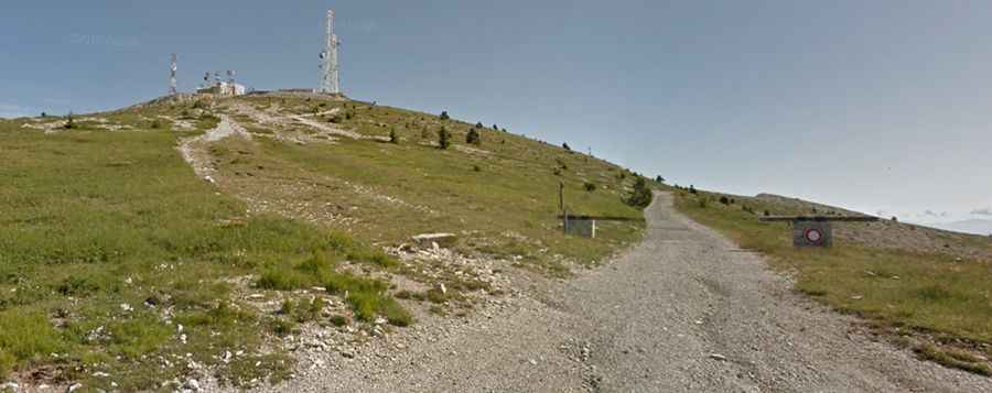
The summit is crowned with several communication towers and antennas, which are visible from miles away. Beyond the technical installations, the top of the mountain offers a spectacular 360-degree panoramic view. On a clear day, you can see the Durance valley, Forcalquier, Manosque, and Oraison to the south, while the white cap of Mont Ventoux dominates the western horizon. Visitors should be cautious when walking around the summit area, as vipers are known to frequent the sun-warmed limestone rocks during the summer months.
Is the road to Montagne de Lure unpaved?
While the main road across the ridge (the D53) is paved, the final spur leading directly to the communication towers at the absolute summit is totally unpaved and very steep. The surface consists of loose limestone gravel and sharp rocks that can be challenging for standard tires. For this reason, a 4x4 vehicle is highly recommended for authorized transit. It is important to note that this specific summit track is often closed to private motorized vehicles to protect the sensitive alpine environment, so most visitors complete the final stretch on foot or by mountain bike.
How long is the road to the summit of Montagne de Lure?
The final unpaved ascent starts near the Col du Pas de la Graille, where the paved D53 reaches its highest point. From this junction, the road to the summit is 977 meters long. Over this short distance, the track gains 65 meters in elevation, resulting in an average gradient of 6.65%. However, some ramps are steeper, and the loose surface makes the climb feel more technical than the numbers suggest. The thin air and the exposed nature of the ridge add to the intensity of the drive.
Is the road to Montagne de Lure open in winter?
No, the road to the summit and the higher sections of the D53 are closed during the winter season due to heavy snow and ice. Being set high in the French Prealps, the Montagne de Lure acts as a barrier for storms coming from the north, leading to massive snowdrifts that can block the road until late spring. The ridge is also notorious for its violent winds, which can reach hurricane force, making the unpaved summit track extremely dangerous even when the snow has started to melt.
What are the main hazards when driving the Lure mountain roads?
The primary hazards on the Montagne de Lure are the sudden weather changes and the lack of protection on the steep slopes. The limestone surface becomes incredibly slick when wet, and the narrowness of the summit track leaves no room for error. Additionally, the area is remote; there are no services at the summit, and mobile phone coverage can be spotty. Drivers must be self-sufficient and keep a close eye on the sky, as thunderstorms can develop rapidly over the ridge, turning a scenic drive into a high-risk situation.