An Epic Drive to Col du Lautaret in France's Dauphiné Alps
Col du Lautaret is a high mountain pass at an elevation of 2.060m (6,758ft) above sea level, located in the department of Hautes-Alpes, in the Provence-Alpes-Côte d'Azur region of France. This pass is part of the iconic Route des Grandes Alpes.
Where is Col du Lautaret?
Set high in the Dauphiné Alps, a mountain range in the southeastern part of France, the pass marks the boundary between the valleys of the Romanche and the Guisane. The summit provides good views of La Meije to the south-west, the Grand Galibier to the north and over several summits of the Massif des Ecrins.
When was the road to Col du Lautaret built?
Construction of the road started in 1880 and was completed by the blasting of a tunnel through to the summit in 1891. It has been a frequented passage since Roman times. At the top of the Lautaret you will also find places to eat or grab a drink and a rest.
Can you drive through Col du Lautaret?
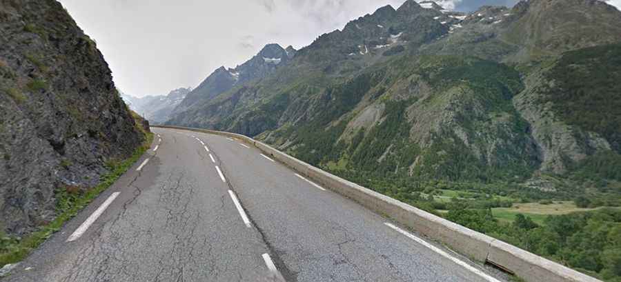
The road to the summit is totally paved. It’s called D1091. The road is 96.5 km (59.96 miles) long, running west-east from Vizille (in the Isère department) to Briançon (in the Hautes-Alpes department). The western approach features a series of tunnels, some stretching up to 800 meters.
Can you climb Col du Lautaret from Galibier?
The pass is located 8km to the south of Col du Galibier, via the spectacular and narrow D902 road. The road leads to Saint-Michel-de-Maurienne. Often ignored because of its location below the iconic Col du Galibier, Col du Lautaret is still a huge climb.
How steep is Col du Lautaret?
Col du Lautaret is a legendary pass in the French Alps and has been featured many times in Tour de France race. Starting from Briançon, the ascent is 27.75 km long. Over this distance, the elevation gain is 853 meters. The average percentage is 3.1 %. And starting from Le Clapier, near Le Bourg-d'Oisans, the ascent is 34.16 km long. Over this distance, the elevation gain is 1.312 meters. The average percentage is 3.8 %.
Is the Col du Lautaret open?
The pass is usually open year round but drivers should be wary of winter-induced restrictions or closures stemming from hazardous conditions. It’s said to be France's highest pass open to vehicular traffic all year round.