The legendary Col de la Madeleine is one of the greatest cycling climbs
Col de la Madeleine is a high mountain pass at an elevation of 1,998m (6,555ft) above sea level, located in the Savoie department of France. It’s one of the most emblematic French Alps mountain passes.
Where is Col de la Madeleine?
The pass is located in the Auvergne-Rhône-Alpes region, in the southeastern part of France.
When was the road to Col de la Madeleine built?
The Col de la Madeleine has been known since Roman times. The decision to build the current road was taken in October 1949 to link the valleys of the Maurienne and the Tarentaise, and the inauguration took place in July 1969 in the presence of Savoyard Minister Fontanet.
Is Col de la Madeleine paved?
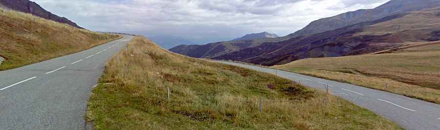
Located in the French Alps, the road to the summit is entirely paved. It’s called D213 (part of the scenic Route des Grandes Alpes).
How long is Col de la Madeleine?
The pass is 37.3 km (23.17 miles) long, running south-north from Sainte-Marie-de-Cuines to La Léchère les Bains. It’s one of the very toughest climbs in France.
Why is Col de la Madeleine famous?
It is one of the more well-known French mountain passes, much because of the frequent visits by the Tour de France over the years. The pass is pretty steep, hitting a grueling 13.5% of maximum gradient through some of the ramps. It’s a mountain relatively difficult to climb, especially from La Chambre, where the slope is steep and relentless. The northern approach from Bonneval is longer but with a lower slope and some passages where you can take some rest, in particular a three-kilometer descent halfway through. It is a climb for pure climbers and for those who like to ride and enjoy the surroundings and the journey. On both sides of the Col de la Madeleine mountain pass, cycling milestones are placed every kilometer. They indicate the distance to the summit of this iconic climb, the current height, and the average slope in the following kilometer.
Is Col de la Madeleine open in winters?
Accessibility is largely limited to the summer season. It is usually closed from November to the beginning of June, but it can be closed anytime when the access is not cleared of snow.
Is Col de la Madeleine worth the drive?
Perched at nearly 2,000 feet, its summit offers a stunning panorama of the Mont Blanc and Lauzière massifs. West of the pass, a brutal unpaved road climbs up to Le Gros Villan, at 2,522m (8,274ft) above sea level. It’s very complicated with very steep slopes (22.41% average slope) and exposed turns but therefore rather exciting.