Colle delle Selle Vecchie: Driving the Alta Via del Sale Border Track
Colle delle Selle Vecchie (known in France as Col de la Celle Vieille) is a high mountain pass at an elevation of 2,099 meters (6,886 ft) above sea level, located on the border between France and Italy. Situated within the Ligurian Alps, the unpaved track through the pass forms part of the famous Alta Via del Sale, a former military route connecting the Province of Cuneo in Piedmont with the Alpes-Maritimes department.
| Road facts: Colle delle Selle Vecchie | |
|---|---|
| Location | France-Italy Border (Piedmont / Alpes-Maritimes) |
| Elevation | 2,099 m (6,886 ft) |
| Road System | Alta Via del Sale (Former Military Road) |
| Surface | Unpaved (Crushed limestone and loose white gravel) |
| Access | Seasonal (Regulated toll road for motorized vehicles) |
What is the road surface like at Selle Vecchie Pass?
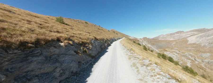
The driving surface over the pass consists entirely of a loose, unpaved bed of white limestone gravel and sharp broken stones. The shelf is exceptionally narrow, measuring between 2.5 and 3 meters wide, allowing space for only one 4x4 vehicle at a time. The mountain track is flanked by vertical rock faces on the inside and sheer, unprotected drops into the alpine valleys on the outside. The trail lacks guardrails or stone barriers, and heavy spring water runoff frequently erodes the outer gravel shoulders, leaving deep ruts along the edge of the limestone cliffs.
Is a 4x4 required to drive the Selle Vecchie mountain road?
A high-clearance 4x4 vehicle equipped with all-terrain tires is mandatory to complete the climb. The shifting nature of the loose white gravel causes standard two-wheel-drive cars to lose traction instantly on the tight, unbanked switchbacks. Motorized access to this sector of the Alta Via del Sale is strictly regulated by a toll system with a daily vehicle limit, and the track is completely closed to motorized transit on specific days of the week to allow exclusive use for hikers and cyclists. The single-lane layout offers no illumination, and the narrow width prevents vehicles from turning around outside of a few designated mountain clearings.
When is the Selle Vecchie Pass open to traffic?
Due to the 2,099-meter altitude, heavy winter snowpacks block the border track from late October until mid-June. The exact opening date depends on mechanical snow clearance operations along the military route. During the summer months, sudden high-altitude thunderstorms can transform the dry white limestone dust into a slick, greasy slurry within minutes, reducing tire grip significantly on the descents toward Limone Piemonte or Monesi. Local authorities close the toll gates immediately during heavy rainfall due to active landslide risks on the shale slopes.
What are the dangers of the high altitude on this border road?
The primary physical hazards at Colle delle Selle Vecchie are the steep vertical drops and the tight space constraints. At nearly 2,100 meters, atmospheric pressure drops, causing older naturally aspirated engines to experience a noticeable loss of power and torque on the climbing ramps. Meeting oncoming 4x4 vehicles or local maintenance trucks forces drivers into long reversing maneuvers on the loose gravel edge to reach the nearest passing turnout. The sharp, uncrushed limestone rocks embedded in the track present a high risk of tire sidewall punctures, requiring robust tires capable of resisting rock cuts on the narrow ledge.
Pic: Matteo Quaglia