Crossing the scary Tunnel de Parpaillon in the Cottian Alps
Parpaillon Tunnel is a defiant high mountain tunnel at an elevation of 2,650m (8,694ft) above sea level, located in the Provence-Alpes-Côte d'Azur region of France. It's one of the highest roads in the country.
Where is the Tunnel de Parpaillon?
The tunnel is located on the boundary between Alpes-de-Haute-Provence and Hautes-Alpes departments, in the Parpaillon massif within the Cottian Alps, in the southeastern part of the country. The tunnel connects the Ubaye Valley to Embrun. This is a very classic road pass in the Alps and was used in earlier days in the Tour de France race.
When was the Tunnel de Parpaillon built?
The tunnel was built by the French Army starting in 1891 to facilitate the movement of troops guarding the border with Italy. Works on the road and tunnel lasted until 1911, although the tunnel was completed in 1901. Once a key route for military supplies, the road was abandoned in favor of the lower Col de Vars, a paved road which could be kept open in winter.
Is Tunnel de Parpaillon open in winters?
Today, the road through the tunnel is totally impassable from October to May. Over a century ago, for many years, this was the highest road in France.
How long is Tunnel de Parpaillon?
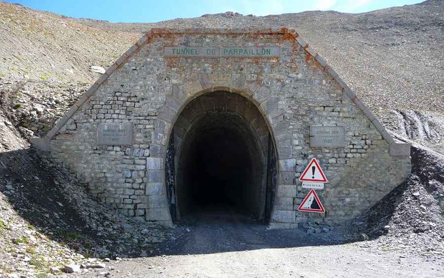
This famous mountain tunnel, one of the highest in Europe, is arched in the middle part and has a total length of 520 meters (1,710 ft).
Is Tunnel de Parpaillon safe?
It’s in terrible conditions. The tunnel contains a lot of ice and water and is totally dark. It can be scary and highly recommended to stay outside. Long since abandoned, the spot is both uplifting and yet desolate in its remoteness, but the views along the road are breathtaking.
How to reach Tunnel de Parpaillon?
The old military road through the tunnel is called D29 (southern side) and D39T (northern side). It is 39.6km (24.60 miles) long, running from La Condamine-Châtelard (in the Alpes-de-Haute-Provence department) to Embrun (in the Hautes-Alpes department). It’s a very challenging unpaved road with narrow parts and some drop-offs. The route has fallen into disuse, and roughly the top 10 kilometers of both sides are rough, stone-filled roads – and the first half is very bumpy. At the high elevations part, the track becomes more tortuous, finally tightening into a seemingly endless hairpin ascent, repeatedly crossing and re-crossing a deep gully gouged by torrents of rain and melt-water cascading down to the valley floor far below. A 4x4 vehicle is required. The road is steep, hitting a 13% maximum gradient through some of the ramps.
2024 Update:
Due to a severe thunderstorm, the tunnel is closed indefinitely following a landslide that caused significant structural damage.