Col du Galibier is an iconic Tour de France climb
Col du Galibier is a high mountain pass at an elevation of 2.645m (8,678 ft) above sea level, located in the French Alps. The legendary road to the summit is one of the most impressive climbs in the country.
Where’s Col du Galibier?
The pass is situated near Grenoble, on the boundary between the Hautes-Alpes department (in the Provence-Alpes-Côte d'Azur region) and the Savoie department (in the Auvergne-Rhône-Alpes region), in the southeastern part of the country.
How long is Col du Galibier?
The road to the summit is entirely paved and designated as D902. The pass spans 43.3 km (27 miles), running north-south from Saint-Michel-de-Maurienne to D1091 road. It culminates at the Tunnel du Galibier, ranking alongside the Col de l'Iseran, 200m (650ft) higher, as one of the highest passes in France.
Is Col du Galibier worth it?
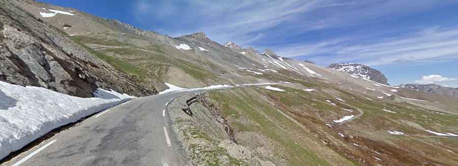
The drive offers magnificent views on both the ascent and the descent. At the summit, visitors are greeted with beautiful scenery; a nearby viewpoint provides an opportunity to admire and identify surrounding peaks such as Meije, Grand Galibier, and even Mont Blanc. Cafes and food vendors are available at the summit.
How hard is Col du Galibier?
The road to the summit, part of the scenic Route des Grandes Alpes, presents a significant challenge with numerous turns and steep inclines, reaching a maximum gradient of 13.1% through some sections. It's crucial to consider the effects of altitude, which become noticeable from 2000 m. This climb is not to be underestimated.
Is the Col du Galibier open?
Situated high between the massif d'Arvan-Villards and the massif des Cerces in the French Dauphiné Alps, this road is typically open from June 1st to October 31st, depending on snow conditions. Opening and closing dates are subject to snowmelt and snowfall each year. It stands as one of the highest roads in the country, named after Le Grand Galibier, the mountain peak at 3.228 meters towering over the Col.
When was the road to Col du Galibier built?
The first road through the pass was constructed in 1876 for military purposes, following the existence of a mule track over Galibier prior to that year. In 1911, a semblance of a road was completed, coinciding with the first Tour de France ascent. The paved road to the summit was constructed in 1976, replacing the Tunnel du Galibier as the primary passage. Until its closure in 1976 due to poor condition, the tunnel served as the only point of passage at the top. It reopened in the summer of 2002 after extensive repairs. Riders had to take the D902B road between 1976 and 2002, while the new road over the summit was built.
Why is Col du Galibier famous?
The iconic road through the pass holds significant historical importance in cycling. It often serves as the highest point of the Tour de France. During its first Tour appearance on July 10, 1911, only three riders managed to ascend the summit without walking. In 1935, Francesco Cepeda became the first cyclist killed in the Tour de France while descending the lower slopes of Galibier below Lautaret. A monument to Henri Desgranges, the founder of the Tour de France in 1903, stands at the south entrance to the tunnel. The 2013 Giro d'Italia also climbed the Col du Galibier, albeit with a shortened stage due to heavy snowfall.