Driving the narrow Route des Tourres through Gorges de Saucha Négra
The Route des Tourres, which cuts through the Gorges de Saucha Négra, is one of the most obscure and technical drives in the Alpes-Maritimes. This 13.1-kilometer track, branching off the Route des Grandes Alpes, is a vertical lesson in survival. Carved directly into high limestone cliffs and crossing unstable "gray lands," the road hangs hundreds of meters above the Barlatte torrent. It is a world of loose scree, deep ruts, and dark tunnels where the mountain feels like it is constantly trying to reclaim the path.
| Road facts: Gorges de Saucha Négra | |
|---|---|
| Location | Alpes-Maritimes, France |
| Distance | 13.1 km (8.1 miles) |
| Hairpins | 17 sharp bends |
| Max Gradient | 12% in specific ramps |
How challenging is the drive to Les Tourres?
The journey from Guillaumes to the remote hamlet of Les Tourres is a high-alert mission. This is a classic example of the balcony roads in France, where the track narrows significantly as it clings to the rock face. You start with the twisty Clot d'Yons section, but the real test begins when you enter the rockfall zones. The surface is an unpredictable mix of smooth earth, loose gravel, and massive ruts. You have to pay close attention to the steering as you dodge larger stones that have dropped from the crumbling cliffs above. In many parts, the road is impassable for two cars to meet, and there are no guardrails between your tires and the void.
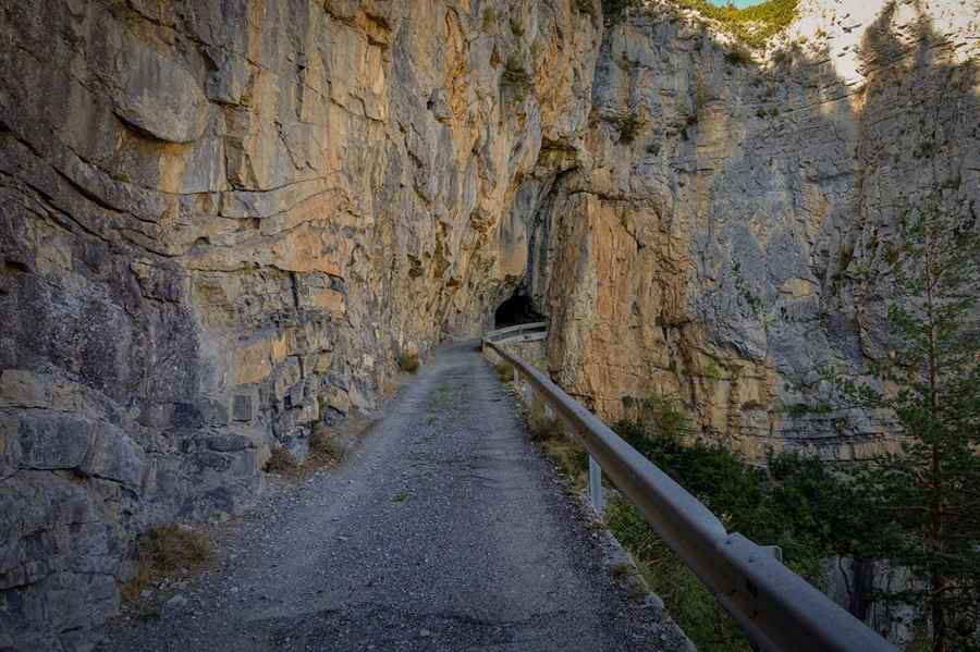
What is the tunnel section like in Gorges de Saucha Négra?
One of the most unsettling parts of this route is a short balcony stretch that leads directly into an eerie, unlit tunnel. Unlike most tunnels, this one has a visibly steep gradient inside, making it a dark hole where you lose all sense of the road surface. Inside, the ground is often damp and slippery, and the width is so tight that mirrors are at risk. Emerging from the tunnel, the road continues to hug the circular dips of the mountain, leading to a small tucked-in bridge. To handle the steepness near the bridge, the authorities have laid short patches of concrete or tarmac for safety, but these only last a few meters before you are back onto the unforgiving rocky surface.
What are the main hazards on the Route des Tourres?
The biggest problem on this drive is the "gray soils" (terres noires). This terrain is extremely weak and prone to landslides; even a moderate rainstorm can wash away entire sections of the track or cover it in a mess of mud and shale. The road is frequently closed after bad weather because the cliffs are literally disintegrating. You will encounter 17 hairpins, some so sharp they require a shunt to clear if you are driving anything larger than a compact 4x4. This is similar to the technical challenges found on the road from Guillaumes to Saint-Martin-d’Entraunes, where the mix of vertical drops and unstable ground is a constant threat.
Is the road to Les Tourres suitable for regular vehicles?
While most passenger vehicles can technically make it in perfectly dry weather, a high-clearance vehicle is a much safer bet. The massive ruts and the deep gravel sections can easily catch a low oil pan or damage the exhaust. The mechanical strain is mostly on the brakes and the transmission, as you will be crawling in low gears for most of the 13 kilometers. When the road is wet, it becomes incredibly slippery, and the signs warning of danger should be taken literally. It is a slow, lonely drive where you might not see another soul until you reach the small church of Sainte-Anne in the hamlet, surrounded by the jangle of distant cowbells and the silence of the high Alps.
Road suggested by: jorge manuel gómez sánchez
Pic&more info: https://www.questel.co.uk/les-tourres/