How to drive the D135 balcony road through Gorges de l'Escharis?
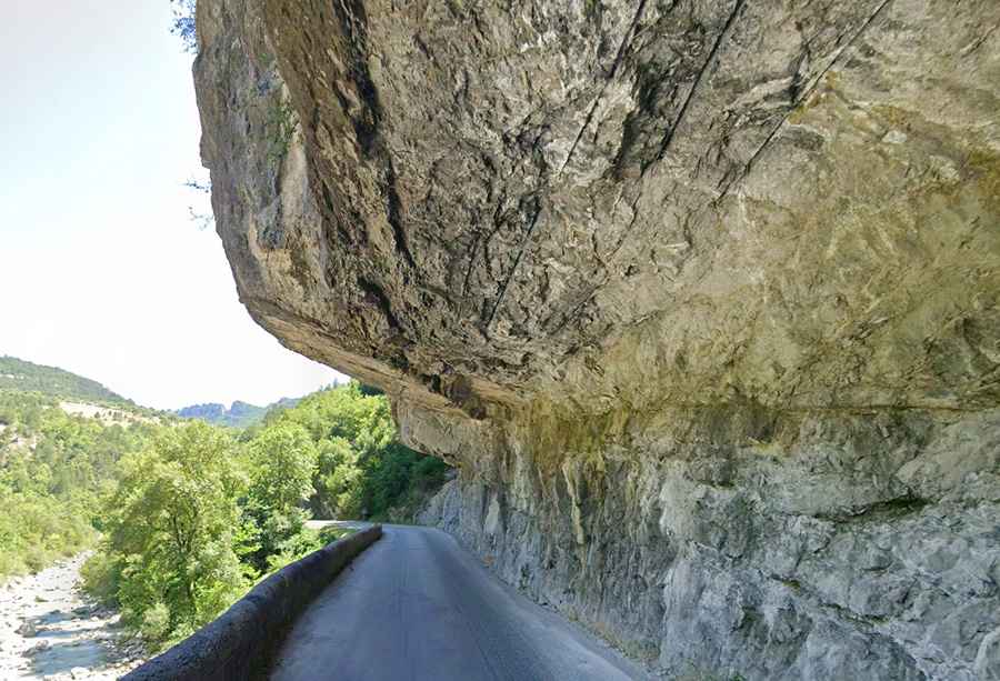
The Gorges de l'Escharis is a deep limestone canyon in the Drôme department of France. The road through the gorge, the D135, is one of the narrowest balcony roads in France. It is a 22.4 km route carved into the cliffs above the Roanne River, where overhanging rocks and the lack of space to pass other vehicles are the main obstacles.
| Road facts: Gorges de l'Escharis (D135) | |
|---|---|
| Location | Drôme, France |
| Road Number | D135 |
| Length | 22.4 km (13.91 miles) |
| Surface | Paved (Extremely narrow) |
| Route | Espenel to Saint-Nazaire-le-Désert |
How narrow is the D135 through the Gorges de l'Escharis?
The 22.4 km journey from Espenel to Saint-Nazaire-le-Désert features sections where the asphalt is not wide enough for two modern cars to pass each other. The road is carved directly into the rock walls, with overhanging stone ceilings that can hit the roof of taller vans or trucks. In the tightest parts of the canyon, there are no safety barriers, leaving the tires just centimeters away from the vertical drop into the Roanne River.
What happens when you encounter oncoming traffic on the D135?
Reversing is often the only way to clear the road. Because the passing points are rare and the curves have zero visibility, you must be prepared to drive backwards on a narrow ledge until you find a wider spot. The variable road width makes it impossible to maintain a steady speed; you have to crawl through the overhanging sections to avoid clipping your mirrors or the top of the vehicle against the limestone.
Are rockfalls a risk in the Gorges de l'Escharis?
Yes. The vertical cliffs above the D135 are unstable, and rock debris on the asphalt is a constant hazard, especially after heavy rain or during the spring thaw. A single fallen boulder can block the entire 22.4 km route, leaving no room to turn around. During summer, when traffic increases, the narrowest sectors near Saint-Nazaire-le-Désert become bottle-necks where a single wide vehicle can stall the entire flow of the gorge.
What should you check before driving the Roanne River valley?
Check the height and width of your vehicle; if you are driving a camper or a large SUV, some overhanging rock sections will be impassable. Verify your brakes and headlights before starting the 22.4 km transit from Espenel. Ensure you have a full tank of fuel, as there are no gas stations inside the canyon. If you see recent rock debris on the road, stop and check the area; the limestone walls of the Drôme are known for sudden rockfalls that can slice through tires or damage the suspension.
Road suggested by: Jorge Manuel Gómez Sánchez