How difficult is the unpaved road to Puigmal in the Pyrenees?
Puigmal, also known as Puigmal d'Err, is a massive mountain peak sitting on the border between France and Spain in the eastern Pyrenees. Reaching an elevation of 2,648m (8,687ft) above sea level, the road west of the summit is one of the highest tracks in the region. This is a wild, unpaved journey that connects the French department of Pyrénées-Orientales with the Catalan comarca of Ripollès. The track is a high-altitude service road that requires a capable vehicle and a driver prepared for the thin air and the absolute isolation of the high border ridges.
| Road facts: Puigmal / Camí del Puigmal | |
|---|---|
| Location | French-Spanish Border (Pyrenees) |
| Max Elevation | 2,648 m (8,687 ft) |
| Length | 23 km (14.3 miles) from Osséja |
| Surface | Unpaved / Gravel / Loose Stones |
| Vehicle Required | High-clearance 4x4 |
How long is the Camí del Puigmal from Osséja?
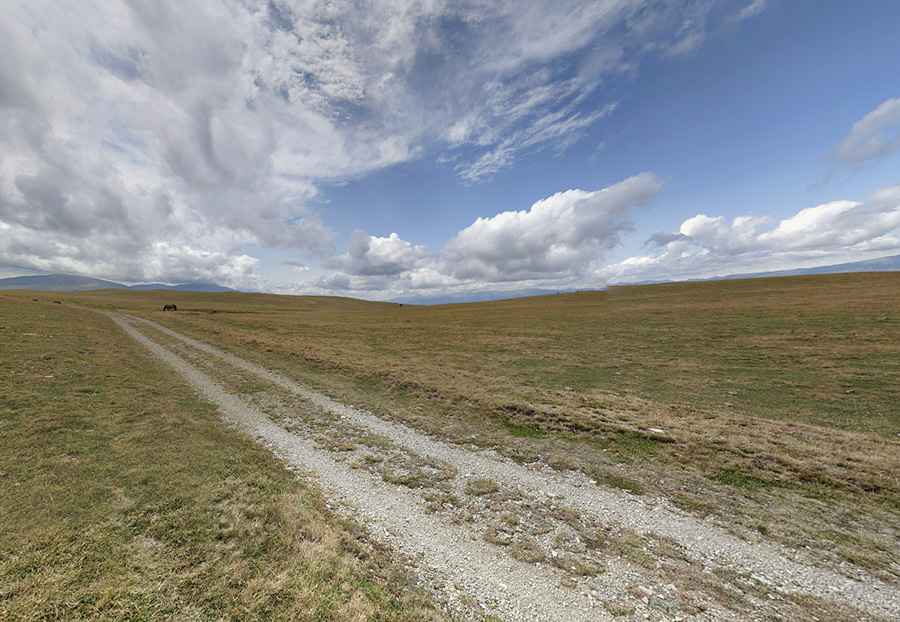
The drive begins in the French village of Osséja and spans 23 km (14.3 miles) of continuous climbing through the forest before breaking into the open alpine meadows. The road, known as Camí del Puigmal, is entirely unpaved and serves as a maintenance track for the ski resort's chairlifts. It eventually leads to a high-altitude parking area near the Tossa del Pas dels Lladres. At nearly 23 kilometers, the trip is a long, slow grind that puts a sustained thermal load on your engine, especially as the air thins and the cooling system becomes less efficient above the 2,000-meter mark.
What are the road conditions on the Puigmal track?
As seen in the high plateaus of the Cerdanya, the surface consists of white gravel and loose stones that have been compacted by ski-resort machinery. While the road is wide in some sections, it is completely exposed to the fierce winds of the Pyrenees. There are no guardrails or barriers, and the track is prone to deep ruts after the spring snowmelt. A high-clearance 4x4 is not optional; you need the traction to manage the loose surface on the steeper ramps and the clearance to avoid the large boulders that occasionally tumble onto the path from the ridges above.
Why is the Pas dels Lladres historically significant for drivers?
The road reaches its most dramatic point near the Tossa del Pas dels Lladres (The Thieves' Pass). Historically, this high-altitude ledge was a primary route for smugglers moving goods across the border between France and Spain to avoid customs. For today's drivers, the "Thieves' Pass" is a technical challenge where the wind can reach hurricane speeds, making it difficult to keep the vehicle stable on the loose gravel. The panoramic views of the Cerdanya valley are impressive, but the focus must remain on the narrow track, as the weather here can shift from sunshine to a thick, freezing fog in minutes, making the 2,648m summit a very dangerous place to be stranded.
Is the road to Puigmal open in winter?
The road to Puigmal is totally impassable during the winter months. Set high in the eastern Pyrenees, the track is buried under deep snow drifts that can linger until late June or even July. Because the road is an unpaved service track, there is no snow clearance provided for civilian vehicles. During the late autumn, the gravel surface turns into a mix of mud and ice that provides zero traction even for the most advanced 4x4 systems. It is best to attempt the 23 km drive only during the peak summer months, and even then, you must carry recovery gear and extra warm clothing, as temperatures at the 2,648m peak can drop below freezing even in August.
Pic: Dani Fenix Siete