D26 Road: Driving the steep 16% ramps from Olivese to Col de la Vaccia
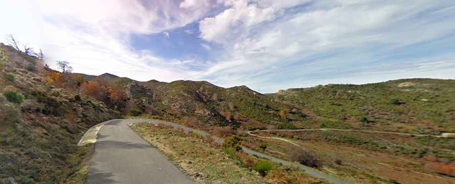
The D26 is a technical mountain road located in the Corse-du-Sud department on the island of Corsica, France. The most critical section of this route runs west-east, linking the village of Olivese with the Col de la Vaccia. This 11-kilometer climb is characterized by its narrow profile and extreme gradients that test the cooling systems and braking capacity of any vehicle navigating the interior of the island.
| Road facts: D26 Olivese to Col de la Vaccia | |
|---|---|
| Location | Corsica, France |
| Length | 11 km (6.83 miles) |
| Max Gradient | 16% |
| Elevation Gain | 717 meters |
Where is the steepest section of the D26?
The D26 starts at the junction with the D757 in Olivese and climbs steadily toward the Col de la Vaccia (1,193m), where it meets the D69. This is a high-mountain environment in the heart of the island, far from the coastal tourist routes. The road is a single-track paved lane where two cars struggle to pass each other without one having to reverse to a wider spot or pull onto the soft, unpaved shoulder.
Is the road from Olivese to Col de la Vaccia paved?
Yes, the entire 11-kilometer section is paved, but the asphalt is often old, abrasive, and uneven. In winter and spring, rockfall is common, leaving granite fragments on the driving line. The road features 16 sharp hairpin turns where the inside radius is extremely tight. Long vehicles or vans must be careful, as the rear wheels can easily lose traction on the steepest parts of the switchbacks if the surface is damp or covered in pine needles.
How steep is the D26 climb?
The climb is relentless, gaining 717 meters of elevation over 11 km. While the average gradient is 6.51%, this figure is misleading; several ramps hit a maximum gradient of 16%. These pitches require the use of first or second gear to keep the engine from stalling. On the descent toward Olivese, engine braking is essential. Relying only on the brakes on a 16% incline will lead to overheating and potential brake fade before reaching the valley floor.
What are the hazards of driving the D26 in Corsica?
The primary hazards are the lack of safety barriers and the unpredictable movement of local livestock, such as pigs and cows, which frequently block the road. The road is physically won from the rock, meaning there is often a vertical wall on one side and a sharp drop on the other. During the winter months, ice patches can remain in the shaded curves of the forest long after the rest of the road has dried. Visibility is limited by the dense vegetation and the constant sequence of blind corners.
Why is the D26 a technical drive?
The D26 is a logistics route for the mountain villages and the Auberge du Col de la Vaccia. It follows the natural topography without the modern engineering found on mainland mountain passes. This results in a high-vibration journey where the driver must be alert for oncoming traffic in the middle of the lane. It is a slow-speed transit where mechanical health—especially the cooling fan and the handbrake—is critical for safety.