Things to Know Before Driving To Great Dun Fell in Cumbria
Great Dun Fell is a mountain peak at an elevation of 848m (2,782ft) above sea level, located in Cumbria, England. It’s said to be the highest paved road in Britain.
Where is Great Dun Fell?
The peak is located in the North Pennines Area of Outstanding Natural Beauty (AONB), in the northern part of the country. It's important to note that due to military activities and restricted access, visitors should respect any posted signs and restrictions in the area.
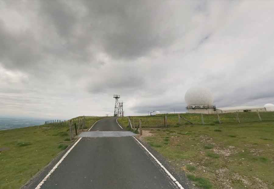
What is on top of Great Dun Fell?
The summit hosts a radar station, a key part of the Air Traffic Control system for Northern England and Southern Scotland. The radar domes are visible for a good forty miles around. The construction of this radar station led to the repaving of a tarred road to the summit, which became Britain's highest road.
How long is the road to Great Dun Fell?
Starting at Knock, the road to the summit is 7.29 km (4.52 miles) long.
Is Great Dun Fell steep?
The road leading to the summit is a popular climb for cyclists. It is known for being one of the steepest road ascents in England. The climb has been dubbed the Mont Ventoux of the North Pennines. The road is often used in cycling events and is a challenging climb for cyclists seeking a demanding route. The elevation gain is 593 meters, with an average percentage of 8.1%. The climb can be split into several distinguishable sections – each no less grueling than the last as the gradient rises towards one-in-four. It hits 16% through some of the ramps.
Can you drive to the top of Great Dun Fell?
The paved road to Great Dun Fell is marked as private from just above the village of Knock and is not open to public motor vehicles. However, it is a bridleway until shortly before the radar station, so it is open to walkers, cyclists, and horse riders.
Is Great Dun Fell dangerous in winters?
Set high in the Pennines mountain range, on a barren landscape, it’s one of the highest roads in the country. The summit greedily hoards snow in winter, and black ice is a serious hazard during the colder months.
Pic: Dan Joyce