Ferry Road: Driving the Tidal Marsh Track of Woodbastwick
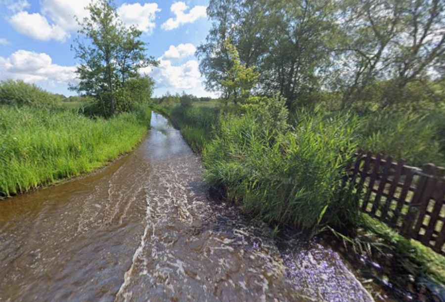
Ferry Road is a narrow tidal route located within the Woodbastwick Fens and Marshes in the Norfolk Broads, England. The single-lane track runs across the low-lying wetlands of the Bure Marshes National Nature Reserve, leading to the seasonal foot ferry terminal directly opposite Horning. It's one of the Periodically Flooded Roads.
| Road facts: Ferry Road (Woodbastwick Marshes) | |
|---|---|
| Location | Norfolk County, East Anglia, United Kingdom |
| Coordinates | 52°41'36.6"N 1°27'49.2"E |
| Flood Length | 0.25 to 0.5 miles (400 to 800 meters) |
| Water Depth | 3 to 10 inches average (can exceed 3 feet during storm surges) |
| Surface | Concrete base / Submerged under river water |
Why does Ferry Road in Woodbastwick flood regularly?
The track is engineered at water-table level across the peat marshes flanking the tidal River Bure. The primary cause of submersions is tide locking, an atmospheric phenomenon where high marine tides from the North Sea restrict the normal outward drainage of the river system. When spring tides coincide with heavy upstream rainfall, the river swells over its low banks, completely submerging Ferry Road under a continuous sheet of water for consecutive days.
What is the driving profile of the Woodbastwick marsh track?
The route features a rigid concrete base hidden beneath layers of river mud, shifting silt, and standing water. The track is extremely narrow and hemmed in by dense, tall reeds on both sides, lacking safety barriers or passing turnouts across the marsh core. A deep, permanent pothole cuts through the concrete base near the mid-point of the track, measuring up to 8 inches in depth. This submerged depression is completely invisible to drivers when the route is flooded, capable of cracking alloy rims and damaging steering racks.
What are the hazards of driving through the Bure tidal floods?
During standard flood cycles, the water depth ranges between 3 and 10 inches over a half-mile stretch, ending roughly 50 yards short of the Ferry Inn pub visible across the water. The flooded track blends entirely with the surrounding marshland, leaving zero visual cues for the road edges. During major winter depressions or storm surges, water levels on the unadopted roadbed can spike over three feet deep, rendering the track impassable to passenger cars. The lack of active drainage means local crews must rely on heavy-duty agricultural tractors and trailers to evacuate stranded vehicles from the riverside boatyards when the tide locks the valley.
What mechanical precautions are required for Ferry Road?
Vehicles attempting the crossing require high ground clearance to clear the central pothole without striking the oil pan. The brackish water of the River Bure speeds up metal oxidation, requiring an immediate high-pressure fresh water flush of the brake calipers, exhaust hangers, and undercarriage components to prevent severe salt corrosion. Due to the lack of agency maintenance on this unadopted road segment, assistance is unavailable if a vehicle slips off the concrete base into the soft peat marsh shoulders.
Road suggested by: jorge manuel gómez sánchez