Driving the Villacher Alpenstraße to the Dobratsch summit
Dobratsch is a high mountain peak reaching an elevation of 2,143m (7,030ft) above sea level, located in the Austrian province of Carinthia. Known for its massive telecommunications tower and historic churches, the summit is accessed via a spectacular but demanding route that transitions from a modern alpine road to a rugged mountain track.
| Road facts: Dobratsch (Villacher Alpenstraße) | |
|---|---|
| Location | Carinthia, Austria |
| Elevation | 2,143 m (7,030 ft) |
| Total Length | 20.5 km (12.7 miles) |
| Average Gradient | 7.81% |
| Max Gradient | ~10-12% in sections |
Where is the road to Dobratsch?
Located near the Italian and Slovenian borders in southern Austria, the peak rises over the city of Villach. The primary access is the Villacher Alpenstraße, a toll road that climbs the massif through the Dobratsch Nature Park. This route is a critical logistical link to the summit's infrastructure, which includes the massive ORF Sender Dobratsch TV tower, the Dobratsch Gipfelhaus refuge, and two high-altitude churches: Windische Kirche and Maria am Stein.
Is the road to the Dobratsch summit paved?
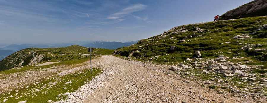
The road surface changes significantly during the ascent. The first 16 km are fully paved, engineered to handle alpine traffic with wide curves and high-quality asphalt. However, the final 4.2 km, beyond the Rosstratte parking lot (Aussichtspunkt Rosstratte), are entirely unpaved. This last sector is a restricted-access gravel track that leads directly to the 2,143m summit. While the paved section is open to all, the final 4.2 km climb requires technical attention due to the loose surface and the steepness of the mountain's upper ridge.
Technical details of the 20.5 km climb
Starting from Villach on the Drava River, the 20.5 km drive is a relentless ascent with an elevation gain of 1,603 meters. With an average gradient of 7.81% and 9 sharp hairpin turns, the drive puts consistent thermal stress on the engine and braking systems. Logistically, the paved section is a pleasure to drive, but once you surpass the 1,732m mark at Rosstratte, the wind and altitude (over 7,000ft) become technical variables. Ensure your vehicle's cooling system is optimized for the sustained low-gear climb, especially if navigating the final unpaved miles toward the Gipfelhaus.
Best time to drive to Dobratsch
Due to its elevation in the Gailtal Alps, the Villacher Alpenstraße is subject to seasonal closures, typically remaining impassable in peak winter. The best time for a full transit is from May to October. Even in summer, the weather at the 2,143m summit can shift rapidly; high-altitude mist can reduce visibility on the 9 hairpins to a few meters. Always check the toll gate reports for current conditions before starting the 1,603m vertical climb from Villach.
Pic: Markus Ortner