Timmelsjoch is the highest pass of the Ötztal Alps
Timmelsjoch Pass, also known as Passo del Rombo, is an international high mountain pass located at an elevation of 2,479m (8,133ft) above sea level, on the border of Austria and Italy, just a few meters below the renowned Passo dello Stelvio, the Queen of alpine roads.
Where is Timmelsjoch Pass (Passo del Rombo)?
Nestled in the Ötztal Alps, the road to the summit is one of the highest paved roads in the Alps, connecting the Ötztal valley in the Austrian state of Tyrol to the Passeier Valley in the Italian province of South Tyrol. Since its completion, the pass road has been an indispensable link between North and South Tyrol.
When was the road to Timmelsjoch Pass (Passo del Rombo) built?
Popular with car and motorbike tourists today, the idea of constructing a road to the summit was conceived in the late 19th century, with the project finally realized in the mid-1950s (between 1955 and 1959). Despite construction being limited to the period between May and November, the road was completed in just 17 months and opened to the public on July 7, 1959, on the Austrian side. However, the connection to Italy was only finalized in 1968. For centuries, the mountain pass served as a vital link between the Upper Inn Valley and the city of Merano, a political and economic center of the historical county of Tyrol.
What is the Timmelsjoch High Alpine Road?
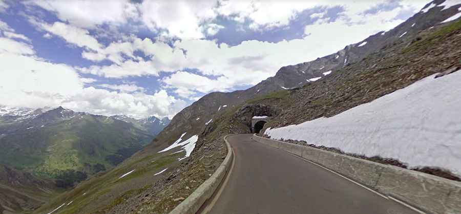
The road to the summit, known as Timmelsjoch Hochalpenstrasse (Timmelsjoch High Alpine Road), is a toll road that spans Austria and Italy. It traverses the glacier landscape of the Ötztal Valley, crossing the Austrian-Italian border and descending into Italy's Passeiertal Valley. Though entirely paved, it presents a challenging drive, featuring 60 turns and 30 hairpin bends, with gradients reaching up to 12.7%. The journey offers a truly unforgettable experience, especially for convertible drivers, motorcyclists, or mountain bikers, with breathtaking views of the Ötztal Alps. It’s one of the scenic Austrian Alpine roads.
How long is the Timmelsjoch High Alpine Road?
Stretching 34.6km (21.49 miles), the road runs from Obergurgl in Austria to Moos in Passeier in Italy, comprising 11.9 km in Austria and 22.7 km in Italy. It ranks among the most scenic Austrian Alpine roads.
Can I drive the Timmelsjoch High Alpine Road?
While there are no restrictions on the Austrian side, allowing unrestricted access to the summit, certain restrictions apply on the Italian side due to narrow, steep road conditions and bridge constructions:
- Cars and motorcycles are permitted.
- Motorhomes and small lorries are allowed, provided they meet specific size and weight limitations.
- Small buses are permitted, with restrictions on length and weight.
- Larger buses and lorries exceeding weight limitations are not allowed.
- Trailers exceeding specified length restrictions are prohibited.
- Cyclists using the Timmelsjoch Pass do so at their own risk and must use bicycle lights.
Is the Timmelsjoch pass open?
The pass road is open daily from 7:00 am to 8:00 pm, typically from the beginning of June to the end of October, owing to the exposed high-elevation terrain. Known as one of the coldest places in the Alps and one of the last to become passable in summer, it is often battered by freezing winds and substantial snow depths, reaching up to ten meters. Additionally, a small stream originating from the surrounding glaciers flows down toward Sölden.
How long does it take to drive the Timmelsjoch High Alpine Road?
Allow approximately 90-100 minutes to complete the drive, with a few stops along the way. Journeying along the Timmelsjoch High Alpine Road, the highest pass in the eastern Alps, offers majestic views of the Ötztal Alps and showcases a masterpiece of road construction. Fantastic vantage points, crystal-clear streams, and steep rock faces accompany travelers from the Ötztal valley to the Italian Tyrol. The entire route is secured with modern safety measures and boasts excellent road conditions.