How to drive the steep road to Darmstädter Hütte in Tyrol?
Darmstädter Hütte is a high-altitude mountain alpine refuge situated at an elevation of 2,383 meters (7,818 ft) above sea level, located in the Tyrolean region of western Austria. The access route to the hut is a restricted, high-gradient mountain track that cuts deep into the rugged terrain of the Verwall Alps.
| Road facts: Darmstädter Hütte | |
|---|---|
| Location | Tyrol, Austria (Verwall Alps) |
| Elevation | 2,383 m (7,818 ft) at the refuge platform |
| Length | 11.6 km (7.2 miles) from St. Anton |
| Average Gradient | 9.1% |
| Surface | Unpaved / Coarse granite gravel and dirt |
How long is the road to Darmstädter Hütte?
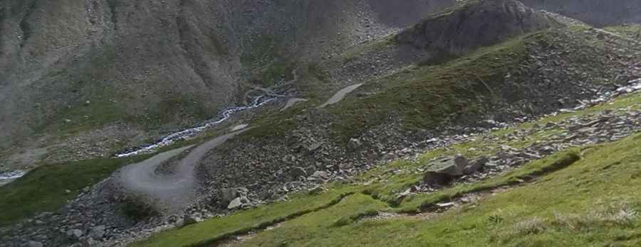
The supply track covers a distance of 11.6 km (7.2 miles), starting from the resort town of St. Anton am Arlberg. The single-lane road tracks south-east along the floor and walls of the Moostal valley, running parallel to the Moosbach torrent before rising sharply up the terminal glacial moraine. The platform averages less than 3 meters in width, flanked by raw rock cutouts on the inside and unprotected vertical drops down to the valley floor on the outer edge, where the unreinforced soil borders are unstable and subject to localized erosion.
How steep is the Darmstädter Hütte road?
The 11.6 km climb is an unrelenting uphill grind that gains 1,056 vertical meters from the valley floor with zero flat recovery segments. The average gradient is a sustained 9.1%, but specific gravel ramps pushing past the tree line hit short pitches well over 15%. On these steeper mountain switchbacks, the surface consists of loose, coarse granite stones that shift constantly under weight, forcing tires to lose traction instantly if a vehicle attempts to stop and restart on the loose grade.
Do I need a 4x4 vehicle for the Darmstädter Hütte climb?
Standard two-wheel-drive vehicles lack the underbody clearance and differential traction required for this alpine track. The roadbed is composed of rough, unscreened crushed stone mixed with drainage channels that cross the path diagonally. Heavy mountain rainfall regularly flushes loose scree and rockfall debris from the upper peaks down onto the track, creating deep gravel banks. Clearing these obstacles requires a high-clearance 4x4 vehicle with a selectable low-range transfer case to crawl over the stone barriers without smashing the transmission casing or tearing the oil pan.
Is the road to Darmstädter Hütte open year-round?
High-altitude alpine winters completely seal the Moostal valley route from early November until late June. Heavy snow accumulation, frequent avalanches from the vertical walls of the Kuchenspitze, and thick permafrost make the 11.6 km climb entirely impassable for wheeled machinery. During the brief summer opening, the road serves as a vital service link for hut keepers and hydro-electric workers. Meeting oncoming supply trucks or maintenance tractors requires reversing along the single-lane platform for hundreds of meters to reach the designated dirt turnouts cut into the rock face.
Pic: Stephen Leopold