How steep is the 4x4 track to Estany de Coma Estremera in Andorra?
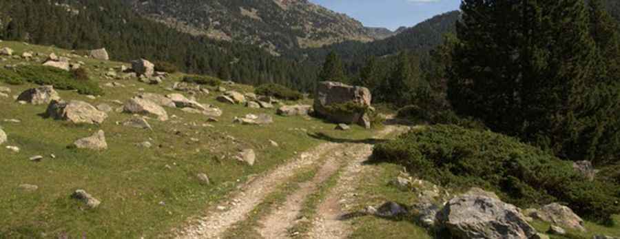
Estany de Coma Estremera is a high mountain lake reaching an elevation of 2,384m (7,821ft) above sea level in the parish of Encamp, Andorra. Located in the rugged Grau Roig sector of the Pyrenees, the road to the lake is one of the highest roads of Andorra. This is a brutal, unpaved service track used by ski resort crews, where the extreme incline and the loose granite surface make it one of the most demanding short climbs in the country.
| Road facts: Estany de Coma Estremera | |
|---|---|
| Location | Encamp, Andorra (Grau Roig) |
| Elevation | 2,384 m (7,821 ft) |
| Length | 2.1 km (1.3 miles) from Grau Roig |
| Average Gradient | 12.14% |
| Max Gradient | 18% |
How long is the climb to Estany de Coma Estremera?
The drive starts at the Grau Roig parking lot (2,129m) and covers just 2.1 km (1.3 miles). However, in this short distance, the road gains 255 vertical meters. This results in a relentless average gradient of 12.14%, with several sections hitting a "wall" of 18%. The track follows the Riu dels Colells, but the focus for any driver must be on the ground; the slope is so steep that standard vehicles will lose traction almost immediately as the weight shifts to the rear and the front tires start to spin on the loose stones. This is a slow, high-torque crawl that puts massive strain on the vehicle's cooling system and clutch.
What are the road conditions on the Coma Estremera track?
The surface is entirely unpaved and consists of rough gravel, loose granite, and deep ruts. This is a maintenance road for the ski lift infrastructure, meaning it is built for heavy machinery and 4x4 trucks, not for passenger cars. The track is narrow and completely exposed, with no guardrails to protect you from the steep embankments. On the 18% ramps, the loose stones act like ball bearings under your tires; if you lose momentum, restarting the climb without sliding backward is nearly impossible. High ground clearance is a basic requirement to avoid smashing the undercarriage on the rocks that often wash out onto the path.
Why is a 4x4 mandatory for Estany de Coma Estremera?
Attempting this climb in a 2WD vehicle is a guaranteed way to get stranded. You need a 4x4 with a low-range gearbox to manage the 18% ramps at a controlled pace. At over 2,300 meters, the engine loses a significant amount of power, and without the extra "grunt" of low gears, you will likely burn out your clutch trying to clear the steepest hairpins. The mechanical stress is constant from the moment you leave the parking lot until you reach the lake. Furthermore, the high-altitude environment means that any mechanical failure turns into a difficult recovery operation in a remote mountain zone.
When is the road to Coma Estremera open?
Due to its elevation, the road is buried under deep snow for most of the year and is only passable from late June to early October. Even in the middle of summer, afternoon thunderstorms are a major hazard in this part of Andorra. Rain turns the dusty granite track into a slick, muddy mess, making the 18% descent even more dangerous than the climb. If the weather turns, the only safe option is to descend immediately using engine braking to prevent the brakes from overheating and failing on the relentless 12% drop back to Grau Roig.
Pic: http://nuriatomas.blogspot.com.es/2011/07/vall-de-la-llosa-vallcivera-illa.html