How to drive the 15% gradient to Collada de Port Negre?
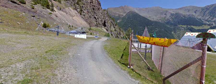
Collada de Port Negre is an international high mountain pass at an elevation of 2,505m (8,218ft) above sea level, situated on the border between Spain and Andorra. This high-altitude peak links Les Valls de Valira in Spain with Sant Julià de Lòria in Andorra. The road to the summit is a technical unpaved trail used primarily for chairlift access within the Pal-Arinsal ski resort. With an extreme vertical profile and a loose surface, it is considered one of the highest and most demanding tracks in the Pyrenees. It’s one of the highest roads in the country.
| Road facts: Collada de Port Negre | |
|---|---|
| Location | Spain-Andorra Border (Pyrenees) |
| Elevation | 2,505 m (8,218 ft) |
| Length | 3.7 km (2.3 miles) |
| Elevation Gain | 566 m |
| Average Gradient | 15.29% |
What are the driving logistics of the 15.29% gradient to Port Negre?
The 3.7 km ascent from the Pal-Arinsal resort to Collada de Port Negre is a logistical challenge due to its sustained steepness. Managing a 566-meter elevation gain over such a short distance results in an average gradient of 15.29%. Technically, this requires a vehicle with a high-torque engine and 4x4 low-range gearing (4L). On the unpaved surface, maintaining a constant torque flow is vital to prevent the tires from spinning on the shale and loose gravel. Any loss of momentum on a 15% uncompacted incline makes a technical restart extremely difficult, putting massive stress on the vehicle's clutch or torque converter.
How to manage traction and surface hazards on the Port Negre trail?
The road to Collada de Port Negre is a chairlift access trail, meaning the surface is not engineered for regular vehicle traffic. Logistically, the track consists of raw mountain earth and loose stones. Technically, the high average gradient shifts the vehicle's weight heavily to the rear axle, which can compromise steering authority. It is a mandatory protocol to use All-Terrain tires with adjusted pressures to increase the footprint. Drivers must also monitor for deep ruts caused by water runoff, as the extreme incline accelerates surface erosion, making the 3.7 km transit technically impassable for vehicles without high ground clearance.
What are the winter closures and seasonal logistics for Port Negre?
Due to its high summit altitude of 2,505m, Collada de Port Negre is typically impassable from October to June. The trail becomes part of the active ski slopes of the resort, covered under significant snowpack. Logistically, there are no clearing operations for wheeled vehicles during the winter. Even during the summer operational window, the road can be closed at any time due to sudden alpine snowfalls or thunderstorms. Technical preparation must include a thorough check of the vehicle's cooling system, as the slow-speed, high-load climb at this altitude increases the risk of thermal failure while airflow through the radiator is minimal.
What are the descent logistics from the summit to Pal-Arinsal?
Descending the 15.29% gradient from Port Negre requires a disciplined braking protocol. Technically, the use of heavy engine braking is mandatory to prevent brake fluid vaporization and rotor warping. Logistically, the narrow nature of the chairlift trail means there is limited room for maneuvering if the brakes fail. Drivers should maintain a slow, controlled descent in the same low gear used for the climb. The "tippy" nature of some sectors, combined with the loose surface, means that lateral grip is minimal, making smooth steering inputs a technical necessity to stay on the narrow track during the 566-meter vertical drop.