Driving the Treacherous Kolyma Highway: Russia's Road of Bones Adventure
Kolyma Highway is an exciting adventure running from Yakutsk (where the coldest temperature ever recorded outside Antarctica was documented) to Magadan, Russia. It was built by prisoners using hand tools in the 1930s, marking one of the most terrifying chapters in Soviet history.
Can you drive the Road of Bones?
Tucked away on the outskirts of the world, through the Russian Far East, the road—part of the M56 route—is locally known simply as Trassa ("The Route") or Kolymskaya trassa ("The Kolyma Route"). As it is the only road in the area, it needs no special name to distinguish it from others. This road is the only route available to arrive in Nizhny Bestyakh (Yakutsk). There’s no choice. Untarmacked, the road shows few signs of use. The area is essentially lawless, undeveloped, barely populated, and unbelievably remote. This area has a bad reputation in the mass mind. Magadan is often associated with prisoners because it used to be one of the biggest gulag distribution centers in the former USSR.
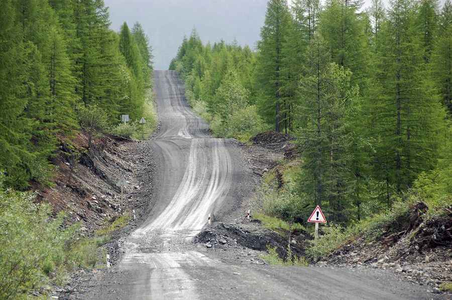
Is the Road of Bones unpaved?
The road is officially known as R504. It’s mostly unpaved and very difficult, with small sharp rocks. Not ideal for a casual Sunday drive. There are several mud sections which are almost impassable in rainy weather, and many sand sections that start suddenly after another corner. The drive provides insight into the dark heart of industrial Russia and the souls who perished in the darkest days of the Soviet Union. Independent travel in the area is a serious adventure, with the very real possibility of death. The road was upgraded in 2008, bypassing a 200km sector between Tomtor and Kadykchan, leaving it completely abandoned. Today, this part of the road is called the Old Summer Road and has been left to the Siberian wilderness with collapsed bridges, flooded roads, and abandoned buildings.
Where does the Road of Bones start and finish?
The road is 1,868km (1,160 miles) long, and it runs west-east from Yakutsk (actually, Nizhny Bestyakh, in Megino-Kangalassky District of the Sakha Republic, on the eastern bank of the Lena River, where the coldest temperature ever recorded outside Antarctica was recorded) to Magadan (the administrative center of Magadan Oblast, on the Sea of Okhotsk in Nagayev Bay). Nizhny Bestyakh is also the largest city built on continuous permafrost. Most houses are built on concrete piles because of the frozen ground.
How long does it take to drive the Road of Bones?
To drive the road will take most people between 4 and 5 days. This road offers jaw-dropping views, unparalleled freedom, and lots of fresh air. The views will linger on our minds long after we've left those places, creating beautiful memories. The road crosses forests, mountains, deserts, and everything in between.
Is the Road of Bones dangerous?
The road is extremely dangerous during rainy spells when the usual clay covering of the road turns into an impassable mud blanket, swallowing trucks and tractors alike. The road is in a state of disrepair and is not traversable by standard road vehicles because of washed-out bridges and sections of road reclaimed by streams. The keys on the road are the extreme temperatures, heavy snow, ice, and reduced visibility, excessive mud in the summer months making it almost impossible to navigate and the ‘Mud Pirates’. It also remains one of the most desolate, with few travelers knowing of the world’s most frozen road—or its tragic history. Due to its surface, traveling here is only feasible in dry summer or during winter when it gets frozen and covered with ice. In other seasons, it’s hardly accessible and completely covered with mud. This drive is extremely dangerous during the winter, which is ten months long because of the heavy snow, the ice, and extremely reduced visibility. But in summers, the conditions of the road become extreme. In July and August, the mud is the worst enemy. Because of the permafrost, there is no asphalt, creating a mud-induced traffic jam every time the summer rains swing in the area. The road gets paralyzed, and it’s chaos, with cars being stuck in a 100-km long car line-ups. After the rain, it can take five hours rather than a few days to drive it. The main risks along the road are death by car accident due to unsafe driving, bad roads, unmaintained vehicles, large trucks that can throw up enormous clouds of dust in dry weather, which can easily hide an oncoming vehicle. Maps are generally out of date. Bears and other wildlife are also a hazard.
Why is it called the Road of Bones?
The road is commonly known as the Road of Bones. The nickname speaks to its tragic history. It was built by the hundreds of thousands of political prisoners who were exiled to the region’s gulags under the Stalin regime from the 1930s to the 1950s, under Dalstroy construction directorate. The first stretch was built by the inmates of the Sevvostlag labor camp in 1932. The work was done with very rudimentary methods, such as shovels and wheelbarrows. The construction continued (by inmates of gulag camps) until 1953. Thousands were shot for not working hard enough, while others died from the gulags’ brutal conditions. The cold was another killer: with temperatures recorded as low as some -70C, the Kolyma is located in the world’s coldest inhabited area. Many of the dead were simply buried beneath the road’s foundations. It is said that the Kolyma Highway cost one death for every meter of road built. In fact, to circulate on it involves traveling over a colossal mass grave that houses many thousands of corpses. The road is treated as a memorial, as the bones of the estimated 250,000–1,000,000 people who died while constructing it were laid beneath or around the road. The ruins of that cruel era are still visible today.
Pic: http://img1.baikalnatu.re/thumbnails/images/90/7f/8c419888cd5c4e4feb00d6627b4f.jpg