How to get by car to Lake Kapetan?
Kapetanovo Jezero is a high mountain lake at an elevation of 1,678m (5,505ft) above sea level, located in the Morača region of Montenegro.
Where is Lake Kapetan?
The glacial lake is located in the western part of the country, high in the Moracke Planine mountain range. At the lake, there are restaurants and a couple of mountain huts.
Is the road to Lake Kapetan unpaved?
The road to the lake comprises paved and unpaved parts. Generally speaking, for this trail, a 4x4 is definitely recommended. That said, a high-clearance 2WD SUV can manage it too, as long as the weather is dry and the driver is cautious. There are two tricky sections worth pointing out. The first is a steep, loose gravel and rock climb that begins right after the tarmac ends. The second is another similar climb along the slopes of Lukavica — also loose and rocky, requiring careful line choice and momentum.
As for infrastructure around the lake, more is being built every year. Kapetanovo has become increasingly popular with both tourists and locals, especially on national holidays. As a result, more sections of the road are being paved over time. It is technically possible to reach the lake mostly via paved roads and some easy gravel/dirt stretches, but that requires local knowledge or a custom route. Most maps and GPS systems only show one or two options — both of which include the off-road segments.
How long is the road to Lake Kapetan?
Starting from Nikšić, the second largest city in Montenegro, the road is 47 km (29 miles) long. Leaving Nikšić, the road follows the Gračanica River and remains paved with clear lane markings for both directions.
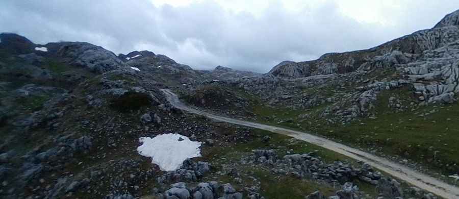
Once you turn off toward Dragovoljci, the road becomes extremely narrow and steep. It’s just wide enough for one vehicle, with a series of tight switchbacks that make it tricky to pass oncoming traffic. After another small village, the pavement ends and the trail gets rough. The initial off-road section includes loose rocks, deep ruts, and some technical climbs. High clearance and 4WD are highly recommended there, though a 2WD SUV with good clearance could manage carefully.
A few miles later, the trail has already smoothed out. From here on, it winds through shaded forest on gravel and dirt, with occasional ruts and tight bends that may challenge longer vehicles over five meters (16+ ft long). After ten to fifteen minutes, the trees give way to wide alpine meadows and the climb continues gently along the slopes of Lukavica. Some ruts are hidden in the grass, and a few steeper patches with bigger stones show up, but overall it’s an easier ride. If the skies are clear, you can even spot the wind turbine farm far in the distance. That scenic stretch takes about twenty minutes.
Eventually, you rejoin pavement, which continues all the way to the lake. The road is narrow and has some potholes, but it’s in decent shape overall. The final push toward Kapetanovo is fairly steep. Heavier rigs over three tons may need to stick to first or second gear for a short while. The last three to two hundred meters are too narrow to pass another vehicle, so it’s best to keep an eye out for oncoming traffic.
Once you make that final climb, the view opens up to the high plateau and the turquoise waters of Kapetanovo Lake. It’s a wild and beautiful destination, and well worth the effort.
How to get to Vojnovac?
A minor gravel road near the lake climbs up to Vojnovac, a mountain peak at an elevation of 2,069m (6,788ft) above sea level.
Road suggested by: Phil Michalski
Pic: Bers Paramoto