How to drive the unpaved track to Ruen Peak?
Ruen Peak is a high-altitude border crossing at an elevation of 2,246m (7,368ft) above sea level, situated on the boundary between southwestern Bulgaria and northeastern North Macedonia. Located in the Osogovo mountain range, the route to the summit is a totally unpaved track. Driving this sector requires a high-clearance 4x4 vehicle to handle the technical logistics of a mountain ridge path that is completely exposed and lacks any form of safety barriers.
| Road facts: Ruen Peak | |
|---|---|
| Location | Bulgaria - North Macedonia Border |
| Elevation | 2,246m (7,368ft) |
| Length | 11.8 km (from Tsarvena Iabalka) |
| Surface | Unpaved (Two-track / Loose stones) |
| Vehicle Requirement | High-clearance 4x4 |
How to navigate the ridge track to Ruen Peak?
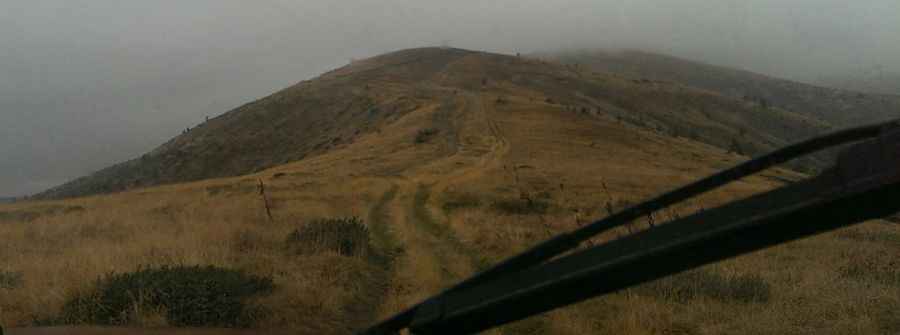
The 11.8 km ascent from Tsarvena Iabalka is a technical transit through a typical high-alpine double-track. The road surface consists of loose rock, dry soil, and patches of grass. The main hazard here is the center of the track; it is often raised and filled with large, embedded stones that can strike the differential or the oil pan of a vehicle with low ground clearance. You must pick your line carefully, often driving with one side of the vehicle on the higher part of the track to ensure undercarriage safety. There are no guardrails or markers, and the track sits on an open ridge where a steering error can lead to a slide down the steep grassy embankments.
What are the technical logistics of the Ruen Peak ascent?
The climb to 2,246m involves a 730m elevation gain that tests your vehicle's cooling and traction. On the loose stone sections, maintaining steady throttle control is vital to prevent tires from spinning and digging into the soft earth beneath. Using a 4x4 system with a locked center differential (if available) is recommended for the steeper, uneven ramps. Logistically, the track is highly susceptible to erosion; after a storm, the dry path can quickly turn into a series of water-filled ruts and mud holes, especially in the lower sections where the forest canopy prevents the ground from drying quickly.
What are the border safety protocols on Ruen Peak?
The track runs directly along the international border between Bulgaria and North Macedonia. Logistically, this means you must remain strictly on the established path. The weather at the summit is unpredictable; high-velocity winds are constant on the ridge, which can make handling a high-profile 4x4 difficult. In case of fog or low clouds, visibility on the unmarked double-track drops significantly, making it easy to lose the driving line. There is no mechanical support or fuel in the Osogovo-Belasica group, so carrying basic recovery gear, such as a shovel and traction boards, is a technical necessity.
Which vehicle maintenance is required for Ruen Peak?
Before attempting the Ruen Peak track, check your tire pressure and sidewall condition. The sharp, jagged rocks typical of this border region are notorious for causing punctures. It is wise to carry at least one full-size spare tire and a reliable jack capable of working on uneven, soft ground. Ensure your vehicle's 4WD engagement is functioning correctly before you leave the paved roads near Tsarvena Iabalka. Once you are on the ridge, you are isolated; the logistics of a recovery at 2,000m are complex and expensive, making preventative vehicle checks the most important part of the trip.
Pic: Георги Панов