What are the driving limits on the road to Mali i Koritnikut?
Mali i Koritnikut is a high mountain peak at an elevation of 1,533m (5,032ft) above sea level, situated on the border between northeastern Albania and southwestern Kosovo. Logistically, the summit is located within the Korab-Koritnik Nature Park. The route is a prime example of a terminal mountain track, where the technical conditions of the terrain eventually exceed the mechanical capabilities of standard off-road vehicles.
| Road facts: Mali i Koritnikut | |
|---|---|
| Location | Albania - Kosovo Border |
| Elevation | 1,533 m (5,032 ft) |
| Length | 9 km (from Rapçë) |
| Surface | Unpaved / Extreme loose rock |
What is the technical difficulty of the road from Rapçë?
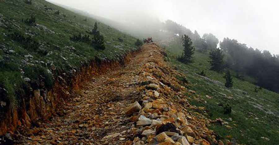
Starting from Rapçë, the ascent to the summit of Mali i Koritnikut spans 9 km. Technically, the road is entirely unpaved and consists of a primitive track with high levels of erosion. Logistically, only 4x4 vehicles with high ground clearance and off-road tires should attempt the first 8 kilometers. The substrate is composed of loose limestone and deep ruts that require precise steering to avoid high-centering the vehicle. As the altitude increases toward the 1,533m mark, the track narrows significantly, leaving no room for maneuvers or passing vehicles.
Why is the final kilometer of Mali i Koritnikut impassable?
Technically, the last kilometer of the route to the summit is impassable even for heavy-duty 4WD vehicles. Logistically, the roadbed disintegrates into a field of large, unstable boulders and steep slopes that exceed the approach and departure angles of any production vehicle. Safety protocols mandate parking the vehicle at the 8 km mark and completing the ascent on foot. Attempting to force a vehicle through this final sector risks catastrophic mechanical failure or a complete loss of traction on the steep, loose shale that characterizes the Koritnik peak.
What are the weather and logistical risks in Korab-Koritnik?
At 1,533m, Mali i Koritnikut is subject to rapid Alpine weather shifts. Logistically, there is no infrastructure or mobile coverage once you leave Rapçë. Technically, the track becomes a mud trap during the rainy season or the spring thaw, making traction nearly impossible even for vehicles equipped with lockers. For anyone navigating this border zone, it is essential to carry recovery gear and auxiliary fuel, as the mechanical strain of the 9 km climb significantly increases consumption. The logistical isolation of the Korab-Koritnik Nature Park means that any recovery operation would be extremely complex and delayed.
Pic: hikingnjeri