Coastal Logistics: How to Navigate the Adriatic Highway and Reach Croatia’s Underwater Frontiers?
The Croatian coastline is a masterclass in geographical diversity, where high-altitude limestone peaks meet the deep trenches of the Adriatic Sea. For the technical traveler, navigating the iconic Adriatic Highway (Jadranska Magistrala) is the primary mission, but the logistics of the region extend far beneath the surface. From the shipwreck-laden waters of Istria to the deep-water caves of Dubrovnik, reaching these aquatic nodes requires precise transit planning. This guide analyzes the logistics of coastal exploration, linking the vertical challenges of the Dinaric Alps with the submerged history of the Adriatic.
| Adriatic Transit & Expedition Matrix | |
|---|---|
| Primary Coastal Route | Adriatic Highway (D8 Road) |
| High-Altitude Access | Sveti Jure & Mount Vojak |
| Submerged Logistics | Shipwrecks (Baron Gautsch) and Blue Caves |
| Cross-Border Protocol | Dubrovnik to Montenegro (Bay of Kotor transit) |
Vertical Extremes: From Mount Vojak to the Istrian Depths
The Istrian peninsula offers a unique logistical contrast. While the road to Mount Vojak provides a technical ascent with panoramic views of the northern Adriatic, the waters below contain some of the most significant maritime wrecks in Europe. Auditing the roads of Istria leads to sites like the *Baron Gautsch*, a passenger ship sunk in 1914. Reaching these coordinates requires an understanding of both high-altitude driving protocols and the specialized logistics of technical diving at depths of 40 meters.
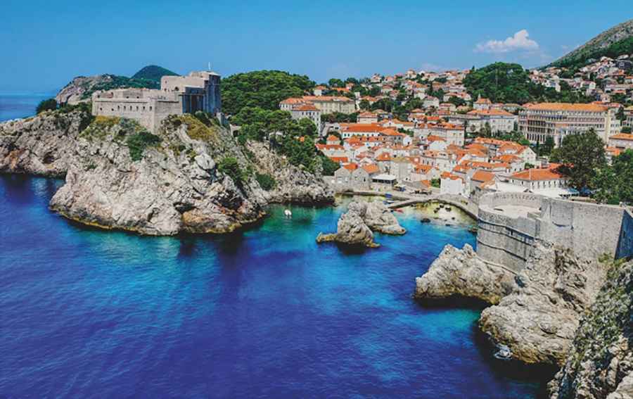
The Southern Corridor: Dubrovnik and the Road to Montenegro
Dubrovnik serves as the southern anchor for the Adriatic Highway. This region is a node for cross-border logistics, especially for those planning a mission into Montenegro. Navigating the Bay of Kotor requires a scenic but demanding two-hour transit from the port of Dubrovnik. The underwater topography here mirrors the ruggedness of the Biokovo range—home to the extreme road to Sveti Jure—with deep caves and a biodiversity of over 600 fish species that thrive in the karst-filtered waters.
Submerged Infrastructure: Shipwrecks as Historical Nodes
For history enthusiasts and technical divers, the Adriatic floor acts as a museum of past logistical failures. Near the coast of Rovinj, the World War II wreck of the *Coriolanus* serves as a poignant reminder of the region's intense maritime history. Similarly, near Dubrovnik, the *Taranto* merchant ship lies on the seafloor. Accessing these submerged sites is a logistical operation in itself, requiring support vessels and precise GPS coordination to navigate the coastal roads and ports effectively.
Advanced Exploration: Tetra Diving in Mljet National Park
Mljet National Park, accessible via ferry-linked roads from the mainland, is a UNESCO-protected region that requires specialized permits. The park is famous for its saltwater lakes and a unique technical diving method known as Tetra Diving. This system utilizes a tethered buoy to support oxygen tanks, allowing for extended missions of up to 12 hours beneath the surface. This high-endurance approach is the underwater equivalent of a long-distance expedition on the Adriatic Highway.
Conclusion: The Full Spectrum of Adriatic Exploration
Croatia offers a diverse operational theater that extends from the highest peaks of the Biokovo range to the depths of the Adriatic Sea. By integrating your transit on the Adriatic Highway with a technical audit of the coastline’s underwater assets, you experience the full scale of this unique region. Whether you are navigating the hairpins of Sveti Jure or exploring the ruins of a century-old shipwreck, professionalism and preparation are your primary tools. Plan your route, verify your dive logs, and focus on the road. The Adriatic’s hidden world is waiting.