National Road 20: inclement weather, typhoons and hurricanes in Cuba
Carretera Nacional N°20 is a spectacular coastal road located in the southeastern area of Cuba. The road links Santiago de Cuba and Niquero, through the Turquino National Park.
Is National Road 20 in Cuba paved?
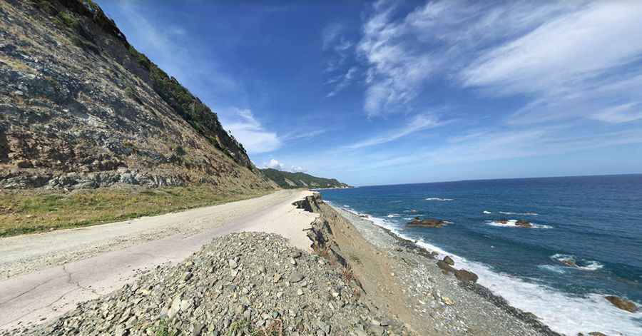
The road was entirely paved, but portions of the road have been destroyed due to inclement weather, typhoons, and hurricanes, and turned into gravel and sand. The road is in poor condition; in some sections, there is only dirt, but restoration is on its way. Ride it if you dare.
How long is National Road 20 in Cuba?
The road is 216km (134 miles) long. It hugs the spectacular Caribbean Sea coast along the Sierra Maestra mountains. Cuba's Carretera Nacional N20 is narrow, in some places only wide enough for one vehicle, and in many places bordered on one side by cliffs and on the other side by the sea unprotected by guardrails. Portions of the road may be temporarily closed due to inclement weather that can cause local flash floods that cover the road with seawater.
Where does National Road 20 start and end?
The road begins in Santiago de Cuba, the second-largest city in the country and the capital city of Santiago de Cuba Province in the southeastern area of the island. After some kilometers, the road enters the Turquino National Park (sometimes called Sierra Maestra National Park), a National Park in southeast Cuba, protecting Cuba's highest mountains rising to 1994 m above sea level. It was important during the Cuban revolution as the first guerilla stronghold, with the original guerilla camp now being a historical site and museum. The national park has within its area a showcase ecological village and several field stations, including the highest building on the island. The road ends in Niquero, a municipality and town in the Granma Province located in the coastal region of the province, bordering the Gulf of Guacanayabo.
Pic: Roger Deuber