Driving the sensational road to the Remarkables in Queenstown
The Remarkables is a ski resort situated at an elevation of 1,622m (5,321ft) above sea level, located in Otago on the South Island of New Zealand. It’s one of the highest roads in the country.
Can you drive to the Remarkables?
Perched high on the southeastern shore of Lake Wakatipu, the road to the resort is named Remarkables Road. It stretches 13.2 km (8.2 mi), commencing at the paved State Highway 6 just south of Queenstown and Frankton. A chairlift service road (-45.057682, 168.808085) at the resort ascends to 1,844m (6,049ft) above sea level.
Is it safe to drive to the Remarkables?
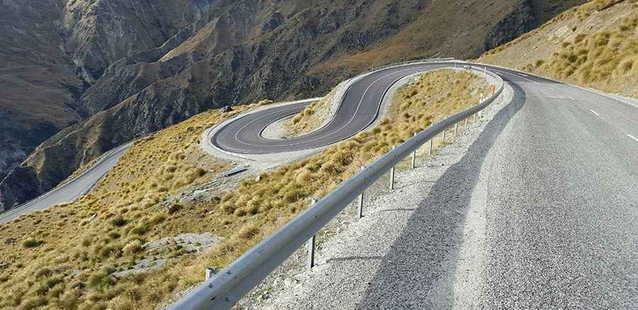
The road to the resort is relatively narrow in parts but offers stunning scenery as the highest sections are above the clouds. It was once considered one of the most dangerous roads in the country, but numerous safety rails have been installed, making it less treacherous. The first 10km of the access road is now sealed, and the remaining 3km is unsealed but in good condition. The road is predominantly steep with numerous sharp turns—requiring the use of bottom gear.
Is the Remarkables Road steep?
The road to the summit is exceptionally steep, with a maximum gradient of 15% through some ramps. Beginning at SH 6 road, the elevation gain is 1296 meters, and the average gradient is 9.81%.
Do you need snow chains to drive to the Remarkables?
The road is generally open year-round, but it may close if not cleared of snow. After snowfall, the road can be treacherous, and carrying snow chains is advisable. Signs along the route will indicate whether chains are required for 2-WD or 4-WD vehicles. Shuttle bus services are available if you prefer not to drive.
Why are they called the Remarkables?
The mountains are named the Remarkables due to being one of the two mountain ranges globally that run directly from north to south. An alternative explanation from locals suggests that early settlers in Queenstown, upon witnessing the mountain range during a sunset, named them the Remarkables to capture the extraordinary sight.
Is the Remarkables Road worth it?
The drive is highly scenic, taking around 25 minutes without stops. Spectacular views commence almost immediately on the road, with notable viewpoints at the 4km and 6km marks, offering stunning perspectives over the lake and the confluence of the Shotover and Kawarau Rivers.
Pic: https://www.stuff.co.nz/national/118943097/drivers-to-be-charged-for-summer-use-of-remarkables-road