Travelling The Zigzag, a dangerous road in New Zealand
The Zigzag was part of the old Arthur's Pass road in Arthurs Pass National Park, located in the center of New Zealand's South Island. This section was on State Highway 73 (SH 73), which crosses a mountainous area.
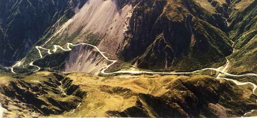
Why Was The Zigzag Considered Dangerous?
The Zigzag was built across a constantly moving scree slope. This stretch of road faced frequent rockfalls and landslides, making maintenance difficult. Over time, the road was moved higher and farther back into the slope, eventually sitting 20 meters higher and 65 meters farther back than it had been seventy years earlier.
What Made Driving on The Zigzag So Difficult?
Driving on The Zigzag was tough due to its steep incline, requiring first gear for most vehicles. The road's sharp corners and frequent rockslides from the mountains added to the challenge. Over time, the road had to be repeatedly moved to avoid constant erosion, flooding, and landslides. Eventually, it became too risky to maintain.
What Happened to The Zigzag?
In 2001, the Ōtira Viaduct was built to replace The Zigzag. This viaduct runs through Ōtira Gorge, bypassing the dangerous sections of the old road and offering a safer route for vehicles on the Great Alpine Highway, officially known as State Highway 73 ('SH 73') and also known as West Coast Road.
Why Was The Ōtira Viaduct Built?
Located within the Arthurs Pass National Park, the major national park in the center of the South Island, the Ōtira Viaduct was constructed to avoid the hazards of the scree slopes and landslides that made The Zigzag unsafe. It provides a stable route through Arthurs Pass, ensuring that drivers can travel the area without the risks of the old road.
Pic: https://www.geocaching.com/geocache/GC4H0H7_deaths-corner?guid=d49c0d19-6386-4b03-8215-aaac93645c4c