Everything you need to know about the tough Dingle Burn Peninsula Track in NZ
Located in the heart of New Zealand's South Island, the defiant Dingle Burn Peninsula Track is one of the toughest tracks of the country.
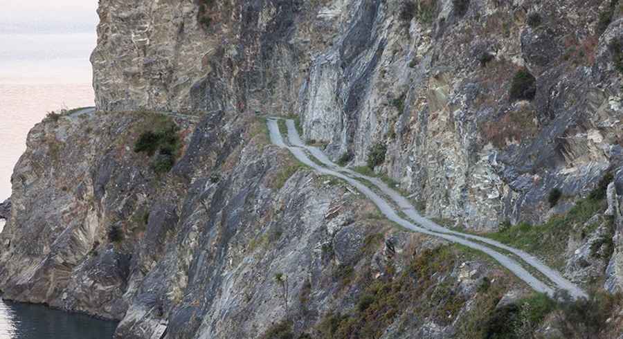
Is the Dingle Burn Peninsula Track in NZ challenging?
Tucked away on the eastern side of Lake Hawea, the track is totally unpaved, steep and exposed with loose shingle. It’s said to be one of the most thrilling and spectacular backroad tracks in the country. It becomes very narrow as it winds its way precipitously around high bluffs.
How long is Dingle Burn Peninsula Track in NZ?
This engineering feat is 56.6 km (35.16 miles) long, running south-north from Gladstone (in Otago) to the border with Canterbury. The most challenging part of the drive is from the start to Dingle Burn (16km long). It’s a scary cliff road.
Can I drive my car through the defiant Dingle Burn Peninsula Track in NZ?
The road is closed to vehicles and crosses private properties. The track will sometimes be closed for up to five hours while stock is moved along the track. The weather can change rapidly. The road is prone to avalanches, usually from May through November. Tell a trusted person your plans and when to raise the alarm if you haven’t returned.
When was the Dingle Burn Peninsula Track built?
Running above Lake Hawea, within the Hāwea Conservation Park, the road was carved out by hand and bulldozers in the 1950’s and opened to traffic in 1963. Rockslides are common. The drive is very scenic and on clear days Mount Aspiring/Tititea can be seen to the north-west.
Road suggested by: jorge manuel gómez sánchez
Pic&more info: https://dingleburn.co.nz/