Sandover Highway is a very remote 4x4 track in the Northern Territory
Sandover Highway is one of the most remote roads in the Northern Territory of Australia. With almost six hundred kilometres of sand hills and corrugations, it’s one of Australia’s best 4WD tracks.
What is Sandover Highway?
The track was built to provide access to the few large stations along the route. Today it is already a popular route for 'grey nomads', driving their caravans from Alice Springs to Mount Isa. Much of the territory that you will cover is historical pioneering country. For most of its distance the Sandover Highway crosses the traditional lands of the Alyawarra people. You will travel for some distance through scrub and spinifex country. The highway is named after the Sandover River.
Where does Sandover Highway start and end?
Located in the central part of the country, the outback unsealed track is 561 km (349 mi) long and runs south-northeast from the Plenty Highway (to the north of Alice Springs) to the Barkly Highway (on the Queensland Border). The highway is a well-formed track with common bull dust hazards and black-soil plains that becomes a quagmire after rain. Although the first part of track can be negotiated by conventional vehicles, use of a four-wheel drive vehicle is recommended after Ammaroo. The road is very rough--only try driving it in a 2wd car, if you're planning to buy a new car.
When is the best time to travel the Sandover Highway?
Be totally prepared and do some serious reading before tackling these regions in Australia. The best time to go is spring or autumn, and the longest run between fuel stops is about 320 km. This is a remote-area experience and travellers should be self-sufficient with everything from water to communications – there’s no mobile network coverage. You'll certainly be out in some desolate country, and even 4WDs breakdown. You will need to make regular checks that spinifex hasn't blocked the airflow to your radiator as it will lead to over-heating and mechanical failure if left.
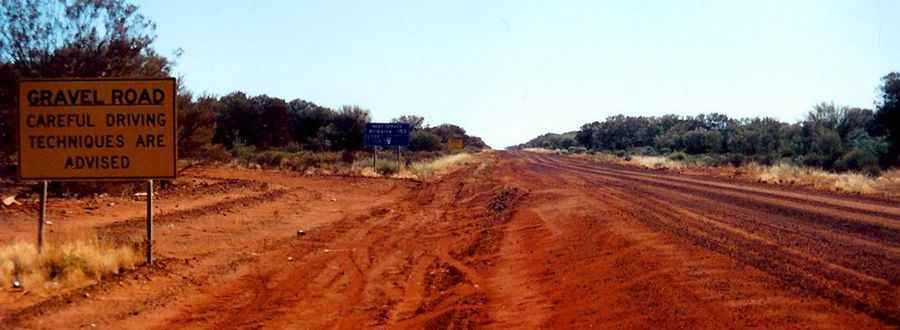
Is the Sandover Highway dangerous?
Careful driving techniques are advised. Carry plenty of water and spare fuel. The road isn’t used much. It’s a real challenging road and a true test of your vehicle and your stamina. Each year the wet season floods the eastern end of the Sandover Highway and Alpurrurulam/Lash Nash becomes completely inaccessible. Black soil is extremely nasty after rain, the resultant quagmire making the road impassable, so check at Arlparra as to the weather conditions. Not even a four-wheel drive vehicle will be able to get through the flooded black soil plains. Flooding can also occur after brief but heavy thunderstorms during the dry season.
Pic: Geerten