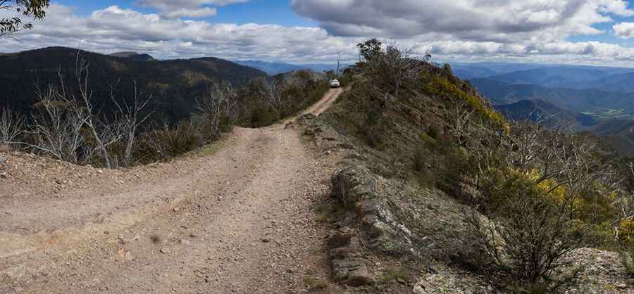
Billy Goat Bluff Trail is a steep track in the Victorian High Country
Billy Goat Bluff Trail is a challenging 4WD fire trail located in Victoria, Australia. The drive is not for the faint-hearted, inexperienced, or unprepared 4WD.
Where is Billy Goat Bluff Trail?
The track is located in the heart of the Pinnacles State Forest in South-Eastern Victoria, within the Alpine National Park.
How long is the Billy Goat Bluff track?
The road is 11.1 km (6.89 miles) long, running from Wonnangatta Road, on Crooked River, to The Pinnacles fire lookout, at 1,415m (4,642ft) above sea level. This tower is manned during the summer fire season.
How hard is the Billy Goat Bluff track?
This steep track edged with cliff faces is totally unpaved. The track at times is refreshed, and some sections become slippery when wet. It should only be attempted by experienced drivers with a 4WD vehicle with low range and high clearance only. It offers a challenging rocky incline that is not for those new to 4WDing. It can be quite narrow in places and challenging to pass oncoming vehicles, so radio communication is crucial. Many 4WD drivers have gotten themselves into trouble while attempting to drive the track. It should always be treated with a great deal of respect and never taken for granted.
How long does it take to drive Billy Goat Bluff track?
To drive the road without stopping will take most people between 1 and 1.5 hours. The view from the top is absolutely breathtaking, and it is well worth the drive. The Pinnacles lookout provides amazing panoramic views of this rugged area.
Is Billy Goat Bluff track open?
Set high in Victorian High Country, the road closes for winter. It’s subject to close anytime between May and January because of changing conditions. Never try it in bad weather. Be prepared for the unexpected. The weather can deteriorate quickly, and snow can fall at any time of the year, so take warm clothing. It can be closed on catastrophic fire danger days as well.
Is Billy Goat Bluff track steep?
The road is said to be one of the tougher climbs in the High Country. It is very steep, hitting a 27% maximum gradient through some of the ramps. The steep rocky parts are insane. Starting at Wonnangatta Road, on Crooked River, the ascent is 11.1 km (6.89 miles) long. Over this distance, the elevation gain is 1249 meters. The average gradient is 11.25%.
Pic: Mark Heuston