Old Telegraph Track is an iconic 4WD track in Cape York
Old Telegraph Track (OTT) is a rugged road accessible only during the dry season located on Cape York in tropical North Queensland, Australia. Be sure to keep an eye out for crocodiles.
Can you drive the Old Telegraph Track?
The road, known these days as the Telegraph Track, passes through some beautiful country with several deep creek crossings and very steep and slippery river banks, along with several patches of deep sand. Bush camps are set up at most creek crossings. The track is fairly narrow, with plenty of turnouts for oncoming vehicles, and you can still see old telegraph poles along the track.
Is the Old Telegraph Track unpaved?
It’s one of Australia’s best 4WD tracks. The surface varies from dirt and sand to rocky slopes, mud, and washouts, and there are a number of great creek crossings.
How long is the Old Telegraph Track?
The road is 350 km (217 miles) long. It’s definitely 4WD only. The track is generally narrow, with some sections being very rocky and eroded. The road follows the original telegraph line through the Peninsula that was used to connect Cairns with Thursday Island. The Telegraph operated from 1885 until 1962 with just two wires sending Morse code via repeater stations, old homesteads, along the way. The line was upgraded to radio in WW2 and was still used for telephone cable until 1987 when it was finally dismantled. It is still possible to locate some of the original steel telegraph poles.
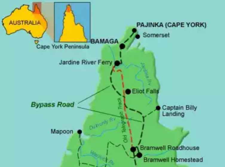
Where does the Old Telegraph Track start and finish?
The Old Telegraph Track runs from Bramwell Junction to Bamaga Road (southern section) and then from Bamaga Road to Jardine River Ferry (northern section).
How long does it take to do the Old Telegraph Track?
To drive the road will take most people between 1 and 2 days on average. Most visitors take the OTT track north and return via the Bypass roads, but the OTT is an integral part of this memorable journey providing adventure, tradition, and stunning scenery.
How hard is the Old Telegraph Track?
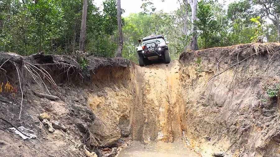
Proper preparation is essential to having a safe, enjoyable trip on this road. If you do choose this route, please check up-to-date information. The drive is challenging enough for the average adventure traveler (not for overly experienced four-wheel drivers). The OTT is accessible only during the dry season (May – October). The road includes some dangers along the track like multiple river crossings (including the danger of crocs), 350 km "without everything," surmounting a two-meter-high vertical wall, mile-long pushing through heavy sand, and managing (calculating) only 1/3 of your average daily mileage.
The Old Telegraph Track features many famous obstacles:
- Palm Creek: This crossing is one of the more difficult ones on the track, so if you manage it without too much trouble, you should be able to negotiate subsequent crossings.
- Gunshot Creek: It's a major obstacle that provides a challenge to most vehicles. It is not advisable to tow campervans or trailers through this crossing – there is a detour track, well-signposted, before you reach Gunshot Creek.
- Cockatoo Creek: This crossing has an uneven rocky bottom but is easy if you take the correct line. The condition of the track improves until it reaches the northern bypass road. Canal Creek is the next challenge. The track then crosses some more very eroded creeks, deep water crossing, before it reaches the deepest crossing, Nolan’s Brook. -The track is then sandy all the way to the Jardine River. It is not advisable to cross the river here, due to soft sand and deep water, not to mention resident crocodiles.
Pic: Remote Offroad