Quaid Road: The Road to Nowhere in Queensland
Quaid Road (Southedge-Wangetti Road Corridor) is a 32-kilometre-long (20 mi) stretch of road in Far North Queensland, in Australia. It links the Captain Cook Highway at Wangetti on the coast, just north of Cairns, to the Mulligan Highway at Southedge, just south of Mount Molloy.
Where is the Quaid Road located?
The road corridor is located in Far North Queensland (FNQ), the northernmost part of the Australian state of Queensland, within the Macalister Range Forest Reserve. It links Wangetti on the coast to Southedge over a distance of 32 kilometers (20 mi).
What is the history of the road's construction?
In November 1983, George Quaid wanted to legally build the road with the approval of the Queensland Government, which was granted. The road was completed in early 1989 through some rainforest areas that were later declared a Wet Tropics World Heritage Area in late 1989. The design and construction were carried out under National Association of Australian State Road Authorities guidelines.
Why did the Australian Government try to prevent the road from opening?
In April 1988, the Australian Government made a regulation under the World Heritage Properties Conservation Act 1983 to prevent the road from opening. This was because the road runs through the sensitive rainforest areas that would later become part of the Wet Tropics World Heritage Area.
What was the road's intended purpose?
The road corridor was initially built as a private access road and a future potential supplementary route to the Atherton Tableland and the Mulligan Highway, though not as an alternative to the Kuranda Range Crossing. The route is significant because travel times from Cairns CBD to Mount Molloy are cut from 1 hr 45 min to less than an hour.
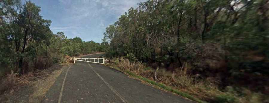
Can I drive the Quaid Road?
The road corridor is currently closed to public access and has a number of locked gates along its route. The closure is due to the Wet Tropics Management Authority not allowing access to certain parts of the road. Motorized vehicular access is by permit only and granted only by the Wet Tropics Management Authority.
Is the road still a controversial issue?
Yes. Ever since its construction as a private road, the road has been a hot issue in Far North Queensland. For years after its construction, the road was suggested as an alternative route to the Atherton Tableland for everyday traffic, as well as for evacuations during cyclones. However, in 1997, the state government announced it was no longer considering gazetting it as a State-controlled road, citing concerns about additional pressure on the Captain Cook Highway.
Was the road considered for use during Cyclone Larry?
Yes. During Cyclone Larry in 2006, all road access to the major regional city of Cairns was blocked, isolating the city for three days. After this isolation, a proposal was made to use the road to truck food into Cairns and evacuate people, but the Queensland State Government again rejected the proposal. Following the Cairns tsunami scare of April 2007, the idea of using the road as an evacuation route became popular once again.