How to drive the unpaved road to Patlian Pass in Kaghan Valley?
Patlian Pass is a high-altitude mountain pass at an elevation of 4,261m (13,979ft) above sea level, located on the mountain ridge that divides the Kaghan Valley (Khyber Pakhtunkhwa) and the Neelum Valley (Azad Kashmir) in northern Pakistan.
| Road facts: Patlian Pass | |
|---|---|
| Location | Kaghan - Neelum Border, Northern Pakistan |
| Elevation | 4,261 m (13,979 ft) |
| Length | 25 km (16 miles) |
| Surface | Unpaved / Rocky Dirt Track |
What is the route of the Patlian Pass road?
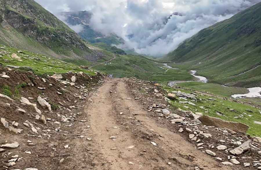
The unpaved road is 25 km (16 miles) long. The track originates near Lawat in the Neelum valley floor, traces the course of the Chuntar Nar river canyon, and climbs steep mountain slopes until it reaches the pass summit at 4,261 meters altitude. Due to the severe incline and rocky surface, completing the 25-kilometer transit requires a driving time of 3 to 4 hours.
Is the road to Patlian Pass unpaved?
The entire alignment is completely unpaved, consisting of a single-lane dirt track mixed with loose shale, granite rocks, and river gravel layers. Engineered between 2019 and 2020, the road features a shelf geometry cut into vertical mountain faces. The lanes have narrow dirt shoulders with steep drops that lack concrete retaining structures or steel safety walls.
What are the vehicle requirements for driving Patlian Pass?
The track requires high-clearance four-wheel-drive vehicles equipped with low-range transfer cases to maintain traction on the loose stone ramps. Water runoff from the Chuntar Nar river and glacial streams cuts across the dirt base, creating sudden washouts and deep mud ruts. At elevations exceeding 4,000 meters, internal combustion engines face torque loss due to low atmospheric pressure.
When is Patlian Pass closed by snow?
At 4,261 meters altitude, the route is blocked by heavy snow drifts for most of the year, restricting vehicle transit to the summer period between late June and September. Heavy monsoon rains during July and August cause sudden rockfalls from the overhanging slate cliffs, blocking the single lane with stone debris. The 25-kilometer mountain sector has zero cellular network signals, fuel stations, or roadside emergency assistance.
Road suggested by: Jorge Manuel Gómez Sánchez
Pic: Haie Mansoor