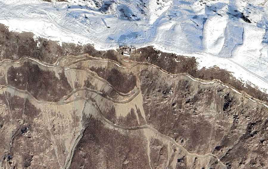
Driving the unpaved border road to Totiano Pass
Totiano Pass (also known as Totiano Kandao) is an international high mountain crossing reaching an elevation of 2,418m (7,933ft) above sea level, situated on the volatile border between Afghanistan and Pakistan. Connecting the Kunar Province with Khyber Pakhtunkhwa, the road is a critical but high-risk logistical corridor in the Hindu Kush region.
| Road facts: Totiano Pass (Totiano Kandao) | |
|---|---|
| Location | Afghanistan-Pakistan Border |
| Elevation | 2,418 m (7,933 ft) |
| Length | 42.5 km (26.4 miles) |
| Surface | Unpaved / Rough Dirt |
| Vehicle Requirement | High-Clearance 4x4 Only |
Where is the Totiano Pass located?
The Totiano Pass spans 42.5 km (26.4 miles), running north to south from the district of Dangam in Afghanistan's Kunar Province to Mamund in Pakistan's Khyber Pakhtunkhwa. Logistically, this track is one of the few remote breaches in the mountain range, used primarily for local tribal transit and military logistics. The 42.5 km route is characterized by its extreme isolation, where the lack of infrastructure means that any mechanical failure requires total self-reliance in a high-conflict zone.
How challenging is the drive to Totiano Pass?
Technically, the road through Totiano Pass is a brutal unpaved track that demands expert-level driving skills. The 42.5 km ascent features countless sharp hairpin turns and sustained steep grades that put extreme pressure on the vehicle's braking and cooling systems. The roadbed is exceptionally narrow, with dangerous drop-offs and no safety barriers. A high-clearance 4x4 vehicle is a mandatory requirement, as the surface is prone to severe erosion, deep ruts, and rock falls that can block the transit without warning.
Is it safe to drive through the Totiano Pass?
Beyond the technical driving hazards, the Totiano Pass is one of the most dangerous roads in the world due to its geopolitical position. Logistically, the pass is often restricted or closed due to ongoing military operations and security threats along the Durand Line. Technically, even with the necessary permits, the route is unprotected and subject to rapid shifts in the security landscape. Most governments strongly advise against travel to this border sector, where the combination of extreme mountain terrain and the presence of militant groups makes motorized transit a high-stakes logistical gamble.
Road suggested by: Hugh Wilson