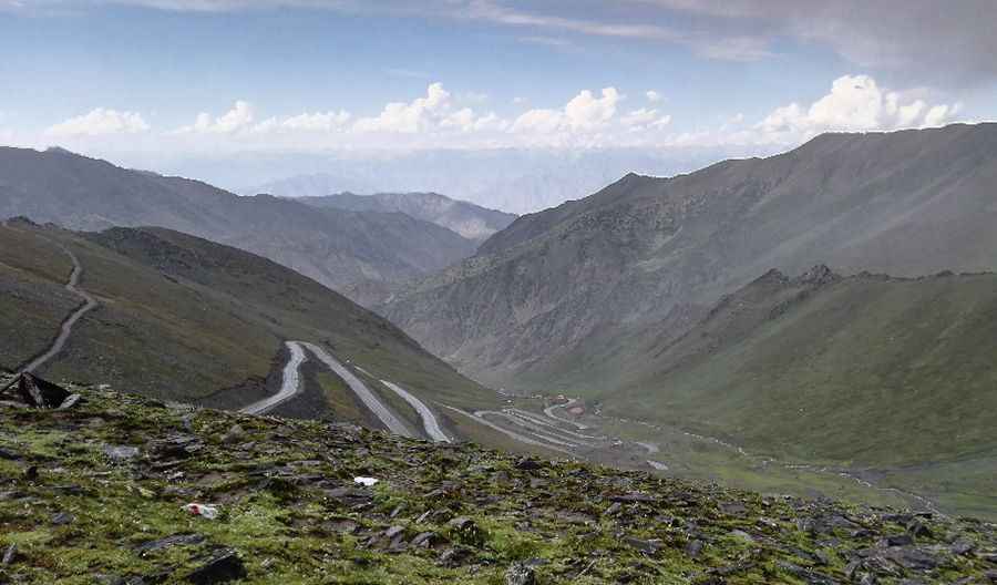
Driving the winding road to the top of Babusar Pass
Babusar Pass is a high mountain pass at an elevation of 4,179m (13,710ft) above sea level located on the boundary between Khyber Pakhtunkhwa and Gilgit-Baltistan provinces of Pakistan. It’s one of the most hairpinned roads in the world.
Where is Babusar Pass?
The pass connects the Kaghan Valley via the Thak Nala with Chilas on the Karakoram Highway. The pass is at a distance of 80 km from Naran. It is on the way to the pass that the Kaghan valley's scenery becomes most dramatic. The area is a famous tourist spot over the years with a number of attractions nearby.
Can a car go to Babusar Top?
The road to the summit, also known as Babusar Top, was recently paved. Due to the unavailability of necessary facilities, one should take eatables and necessary items with them. The road is wide and usable for all kinds of vehicles. It is a typical Pakistani mountain road, with hills on one side and a deep khud (valley) on the other side. Although there are efforts to upgrade the road, most progress has been made on the Chilas side. You should definitely get local advice before crossing the pass. The PTDC in Naran is a good source; in Chilas, try field officers at the Northern Areas Public Works Department (NAPWD) executive engineer office, or Natco drivers on the Babusar village run. The road over the pass was first constructed by the British as an alternate route to connect Gilgit agency with British India. Every year many deaths happen here due to the mountainous slopes, which are among the most dangerous in the world. The most common reason for death is the brake failure of cars due to nexperience. Towards the top of Babusar Pass, the turns are sharper and steeper. Make sure your car’s brakes, exhaust systems, and heater are in good condition.
How long is Babusar Pass?
The road to the summit is called National Highway 15 (N-15). The road is 226 km (140 miles) long, running south-north from Mansehra (the capital of Mansehra District in Khyber Pakhtunkhwa province) to Chilas (the divisional capital of Diamer District in Gilgit-Baltistan).
Is Babusar Pass worth it?
On top of the pass, there is a bridge-like stony minaret, a symbol of the highest place in the area. On the right side, there are snow-covered peaks of Kashmir, while the northeast gives an interesting view of Nanga Parbat. From the pass, the whole panorama lies spread out before the visitor. The views from the top are truly breathtaking. The clouds that previously appeared on the top of mountains now surround you. Looking down from the top, you can see the spectacular road twisting and turning through the mountains. On a clear day, the great Nanga Parbat (26,660 ft) can also be seen from here.
Is Babusar Pass open?
The pass is always covered with snow, but in summer, snow melts, so routes are cleared and it mostly rains there. From the middle of July up to the end of September, the road beyond Naran is open right up to Babusar Pass. However, movement is restricted during the monsoon and winter seasons, but it can be closed anytime when the access is not cleared of snow. A chilly wind blows all the time. The Kaghan Valley is at its best during the summer (months ranging from May to September). In May, the maximum temperature is 11 C (52 F), and the minimum temperature is 3 C (37 F). Security officials may stop you from crossing Babusar Pass after 05:00 PM PST, so make sure to reach Babusar Pass before this time.
Pic: Anwar Swati