Kaligandaki Road: Driving the Unpaved Track over 9 Passes to Kora La
The Kaligandaki Road is a high-altitude unpaved mountain track located in the Mustang District of Nepal. Built by the Nepal Army, this 103 km (64 miles) dirt route cuts through the high-desert region of Upper Mustang, connecting the settlement of Kagbeni with the Chinese border post at Kora La.
| Road facts: Kaligandaki Road | |
|---|---|
| Location | Mustang District, Nepal (Himalayas) |
| Length | 103 km (64 miles) |
| Max Elevation | 4,621 m (15,160 ft) at Kora La |
| Surface | Unpaved (Loose shale, ruts, and deep sand) |
| Vehicle Required | High-clearance 4x4 with low-range transfer case |
How difficult is the drive through the Kaligandaki route?
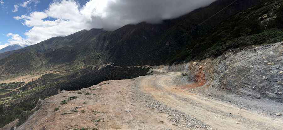
Starting from Kagbeni at 2,800 meters, the single-lane road follows the deep canyon of the Kali Gandaki River before rising into the vertical cliffs of Upper Mustang. The surface is completely unpaved, alternating between deep sand tracks and loose shale paths carved directly out of the rock faces. The road entirely lacks guardrails, concrete barriers, or steel protections against drops into the canyon floor. A high-clearance 4x4 with a low-range gearbox is mandatory to crawl up the steep dirt ramps without spinning wheels or burning the clutch.
The 9 high-altitude passes of Upper Mustang
The 103 km dirt track crosses a continuous chain of 9 mountain passes (La) that accumulate heavy strain on vehicle mechanics and cooling systems:
- Dajori La (3,600m): The initial unpaved climb marked by rocky tracks and deep dust ruts.
- Syangboche La (3,826m): A sector featuring tight, unbanked switchbacks and steep inclines.
- Bhena La (3,838m): A high mud zone heavily damaged by heavy commercial supply trucks.
- Yamda La (3,986m): An exposed ridge path prone to severe water runoff and deep track erosion.
- Nyi La (3,932m): A high-wind crest where lateral gusts hit high-sided 4x4 vans and trucks.
- Mui La (4,142m): A sustained alpine grade that causes radiator temperatures to spike rapidly.
- Tsarang La (3,870m): The descent path toward Lo Manthang, covered in shifting stone debris.
- Morang La (4,292m): An isolated mountain sector with rough-cut rock ledges and zero turnouts.
- Kora La (4,621m): The terminal pass on the Chinese border line, where thin air drops engine power by over 30 percent.
What are the primary hazards on the road from Kagbeni?
Blinding afternoon dust storms known as the Mustang Wind hit the open ridges daily, dropping driving visibility down to zero within seconds. Glacial melt rivers crossing the track are another constant hazard; by mid-afternoon, small streams turn into deep torrents capable of stalling engines or sweeping standard cars off the gravel beds. Because the lane is barely 3 meters wide on cliffside stretches, encountering oncoming local tractors forces drivers into long reversing maneuvers on loose dirt borders.
When is the track to Kora La open?
Heavy winter snowfall typically buries the passes of Morang La and Kora La from December to April, leaving the high border sector completely blocked by snowdrifts. During the summer monsoon months of July and August, heavy rainfall triggers frequent landslides that wash away entire sections of the shale shelves. The route operates with zero commercial gas stations, repair workshops, or mobile phone networks, requiring vehicles to carry auxiliary fuel tanks, two full-sized spare tires, and basic tools.
Pic: Sebastian Kamenz