The Jeep Road to Salleri is How You Reach Everest Without Flying
Most people arrive in the Everest region by air, on a sixteen-minute flight into a runway carved at an angle on a mountainside. There is another way in, and it runs on wheels: roughly 265 kilometres of road from Kathmandu to Salleri, the district headquarters of Solukhumbu, followed by a rough jeep track that climbs to within a few hours' walk of the main Everest trail.
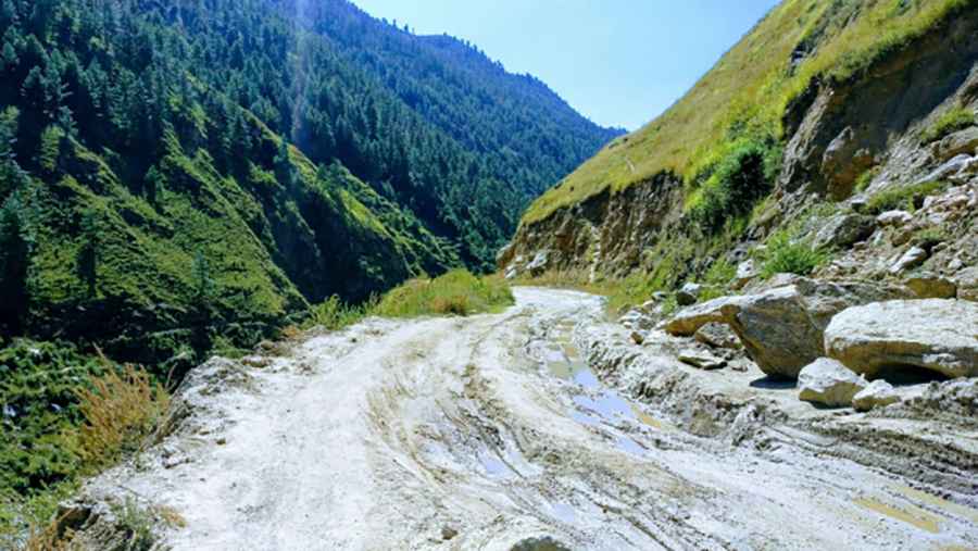
The drive takes a full day, swallows four river valleys, and ends at 2,400 metres. This guide covers the route, the conditions, the costs, and the seasons when the road is worth attempting.
Key Takeaways
- Distance from Kathmandu to Salleri is about 265 km (165 miles), with 8 to 12 hours of driving.
- Salleri sits at 2,469 m (8,100 ft); Kathmandu starts the journey at 1,350 m (4,430 ft)
- The Kathmandu to Salleri section is now blacktop, though patchy in places
- Beyond Salleri, a 38 km unpaved track to the Dudh Koshi bridge takes around 5 hours
- Shared jeep seats run $25 to $35 per person; a private 4x4 costs $150 to $200 for the vehicle
- October to November and March to May are the reliable windows; monsoon brings landslides
Where Does the Kathmandu to Salleri Road Go?
The road leaves Kathmandu on the Araniko route toward Dhulikhel, drops into the Sun Koshi valley, and then turns east through Ramechhap district before climbing north into Solukhumbu. The last stretch delivers vehicles to Salleri and Phaplu, 2.5 km apart, which together form the roadhead for the Solu side of the Khumbu. Trekkers who want to reach the Everest Base Camp without boarding a plane start walking from here.
The first 100 km of the drive shares tarmac with the route to Manthali Airport in Ramechhap, which is where most Lukla flights now depart in peak season. After that junction, the traffic thins out and the road begins to behave like a mountain road rather than a highway.
Why Do Trekkers Drive This Road Instead of Flying?
Two reasons: weather and altitude. Lukla flights cancel for days at a stretch when cloud sits in the valley, and a trekker stuck in Kathmandu burns holiday time at $50 a night. The road runs whether or not the sky cooperates.
The second reason matters more physiologically. Flying into Lukla lifts a body from 1,350 m to 2,860 m in under twenty minutes. Driving to Salleri gains barely 1,100 m over a day and adds three to four walking days before Namche, which is a far gentler introduction to altitude.
Factor | Lukla flight | Road via Salleri |
Cost one way | $200 to $220 | $25 to $35 shared, $150 to $200 private jeep |
Time to trailhead | Under 1 hour | 8 to 12 hours, plus a second jeep leg |
Weather reliability | Frequent cancellations | Runs unless landslides block it |
Extra trek days added | None | 3 to 4 |
Acclimatisation | Abrupt gain to 2,860 m | Gradual, walking approach |
What Makes the Drive Dangerous?
The hazard on this road is not altitude. It is geometry. Long sections are cut as a single lane into steep hillsides above the Sun Koshi and Dudh Koshi, with the drop on the outside unprotected by any barrier. Two vehicles meeting on one of these shelves means one of them reverses, sometimes for several hundred metres, to the nearest widening.
The surface compounds it. Blacktop on this route is laid over unstable hill terrain and breaks up at the edges, so the usable lane is narrower than the road looks on a map. Rockfall scars appear every few kilometres on the cut slopes, and the debris sits where it landed until a grader passes.
Night driving is the real risk multiplier. Buses and cargo trucks use the same lane on blind corners; headlights do nothing for a curve carved into rock, and local drivers set off at 5 am for exactly this reason.
How Long Does the Drive Actually Take?
Eight hours is the figure the Jeep operators quote. Ten to twelve is what the journey takes in practice, once stops, roadworks, and overtaking queues behind trucks are counted.
Segment | Approx. distance | Surface | Typical time |
Kathmandu to Dhulikhel | 30 km | Paved, congested | 1.5 hours |
Dhulikhel to Sun Koshi valley | 60 km | Paved, winding descent | 2 hours |
Sun Koshi to Ramechhap junction | 70 km | Paved, broken edges | 2.5 hours |
Ramechhap to Salleri | 105 km | Paved, steep hill climbs | 4 hours |
Salleri to Thamdanda | 38 km | Unpaved, 4WD only | 4 to 5 hours |
That last row is a separate day for most travellers. The track from Salleri climbs to Thamdanda at 2,780 m and is the section that justifies hiring a driver who knows it.
When is the Road Passable?
October to November and March to May are the two dependable windows, matching the best time for the Everest region on the trail itself. Skies are clear, the surface is dry, and the unpaved section past Salleri holds together.
From mid-June to early September, the monsoon makes this a different road. Landslides close sections for hours or days; the Salleri to Thamdanda track turns to mud that defeats even 4WD, and clearance crews work in the order of road importance rather than tourist convenience. Driving it in those months is a gamble on a schedule.
Winter, from December to February, keeps the road open but adds ice on the high shaded curves above 2,000 m in early morning. Departures after sunrise solve most of that.
What Vehicle and What Does It Cost?
A high-clearance 4x4 is the minimum beyond Salleri. The paved section to Salleri tolerates a sedan in dry weather, though few drivers will take one.
- Shared jeep: $25 to $35 per person, departing early morning from Chabahil and Koteshwor in Kathmandu. Nine seats, usually more passengers than that.
- Private 4x4 hire: $150 to $200 for the vehicle to Salleri, split across up to six people, with flexible departure and stops.
- Public bus: $10 to $15, slowest option, not recommended on the hill sections.
- Salleri to Thamdanda local jeep: arranged in Salleri, priced per vehicle, higher than the per-kilometre rate below because of the surface.
Breaking the journey overnight at Okhaldhunga or Ghurmi costs little and removes the worst of the fatigue from a single-day push.
Where Does the Road End and the Trail Begin?
Salleri and Phaplu are the paved roadheads, and Phaplu has a small airport that serves as a backup to Lukla. Beyond them, construction has pushed the drivable track to Thamdanda, just past Bupsa, which puts jeeps within a few hours' walk of the main Everest trail near Surke.
From Thamdanda the walk to Phakding is manageable in a day, and Namche follows the day after. Trekkers who drive the whole way add roughly three days to the itinerary compared with a Lukla landing, and gain acclimatisation for them.
Road Stats
Route | Kathmandu to Salleri, Solukhumbu, Nepal |
Length | 265 km (165 miles) paved, plus 38 km unpaved to Thamdanda |
Start elevation | 1,350 m (4,430 ft) |
End elevation | 2,469 m (8,100 ft) at Salleri, 2,780 m (9,120 ft) at Thamdanda |
Surface | Asphalt to Salleri, gravel and dirt beyond |
Vehicle | 4x4 with high clearance |
Season | October to November, March to May |
Nearest airport | Phaplu |
FAQs
Is the road to Salleri paved?
The full 265 km from Kathmandu to Salleri is blacktop, with broken edges and patched sections on the hill climbs. Everything beyond Salleri is unpaved.
How many hours is the drive from Kathmandu?
Operators quote 8 hours; 10 to 12 is realistic with stops and traffic. Leaving Kathmandu before 6 am makes the difference.
Can a normal car do this drive?
A sedan manages the paved section to Salleri in dry conditions. The track to Thamdanda needs 4WD and clearance.
Is the road open during monsoon?
It opens and closes. Landslides between June and September block sections unpredictably, and the unpaved stretch becomes impassable.
Are shared jeeps safe?
They are the standard local transport, and drivers know the route well. The discomfort is real: nine-seat vehicles routinely carry more.
Where should you stop overnight?
Okhaldhunga and Ghurmi both have basic lodges and split the drive into two reasonable halves.
Is Salleri or Phaplu the better base?
Phaplu has the airport and slightly better lodges; Salleri has more jeep connections onward. They sit 2.5 km apart.
Does driving in help with altitude?
Yes. The gradual gain and the extra walking days before Namche are a meaningful advantage over a direct flight to 2,860 m.