How to drive the military track with 75 hairpins to Lajyung La?
Lajyung La (also referred to as Lachung La or Lajin La) is an international high mountain pass at an elevation of 5,000m (16,404ft) above sea level, situated on the border between China (Tibet Autonomous Region) and Nepal (Gorkha District). Logistically, this is one of the highest roads in Nepal and China. While the Nepalese side lacks any motorable infrastructure, the Chinese side features a strictly regulated military road that starts from Ru Village in Gyirong County. Access is restricted and requires high-altitude 4x4 equipment.
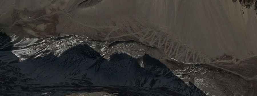
| Road facts: Lajyung La | |
|---|---|
| Location | China (Tibet) - Nepal (Gorkha) |
| Elevation | 5,000m (16,404ft) |
| Length | 14.4 km (from Ru Village) |
| Elevation Gain | 1,111 m |
| Technical Features | 75 hairpin turns / Max gradient 17% |
What are the technical driving challenges of the 75 hairpins to Lajyung La?
The 14.4 km ascent from Ru Village is a high-frequency switchback route, featuring 75 hairpin turns. Over this distance, the elevation gain is 1,111 meters with an average gradient of 7.71%. However, several ramps reach a maximum gradient of 17%. The combination of loose unpaved surfaces and the extreme density of hairpins requires precise steering geometry and constant gear management. High-clearance 4x4 vehicles are mandatory to navigate the tight radii of the turns, where the road surface is often eroded by high-altitude winds and seasonal runoff.
What are the mechanical logistics at 5,000 meters elevation?
Reaching the 5,000m summit of Lajyung La reduces engine power output by approximately 50% due to the decrease in air density. The high-torque demand of the 17% ramps puts an immense load on the transmission and cooling systems. Logistically, since there is no motorable path into Nepal, the entire 1,111-meter vertical drop must be descended back toward Ru Village. This 14.4 km return journey is a critical test for the braking system. It is a mandatory technical protocol to use engine braking in a low gear; relying on the service brakes will lead to thermal failure before reaching the valley floor.
What are the restricted access and border zone protocols?
The road to Lajyung La is classified as a military track and is currently restricted. Logistically, entering this border zone requires specific military permits from the Tibet Autonomous Region authorities. There is no civilian infrastructure, mechanical support, or fuel available within a 50 km radius of Ru Village. Self-sufficiency is a baseline requirement; vehicles must carry a minimum of two full-size spare tires and survival equipment for extreme sub-zero temperatures. In the event of a mechanical failure, recovery operations are logistically complex due to the military nature of the road and the extreme isolation of the Himalaya range.
Vehicle preparation for the Ru Village to Tibet border transit
A heavy-duty 4x4 with All-Terrain tires and reinforced sidewalls is essential for the sharp rocky surface of Lajin La. Before starting the 14.4 km climb, verify the integrity of the steering system and suspension, as the 75 switchbacks will subject these components to extreme stress. It is a safety protocol to check the air filtration system, as the fine dust from the unpaved Tibetan tracks can quickly degrade engine performance at high altitudes. Carry recovery straps, a high-lift jack, and satellite communication tools, as there is no cellular coverage throughout the Gorkha-Tibet border sector.
Road suggested by: Jorge Manuel Gómez Sánchez