How to drive the volcanic track to Khorgo Mountain?
Khorgo Mountain is a dormant volcano situated at an elevation of 2,210m (7,250ft) above sea level in the Tariat district of Mongolia's Arkhangai Province. Located within the Taryatu-Chulutu volcanic field, the crater lies immediately east of Terkhiin Tsagaan Lake. The final approach to the summit is a 1.48 km unpaved track that requires specialized 4WD equipment to navigate the raw volcanic substrate and the irregular ruts of the Khangai Mountains range.
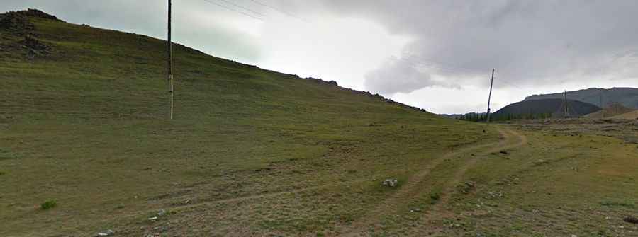
| Road facts: Khorgo Mountain | |
|---|---|
| Location | Arkhangai Province, Mongolia |
| Elevation | 2,210 m (7,250 ft) |
| Length | 1.48 km (0.92 miles) |
| Surface | Unpaved / Volcanic Soil |
| Technical Hazard | Deep ruts and lack of drainage |
What are the technical driving challenges on the Khorgo Mountain track?
The 1.48 km ascent to Khorgo Mountain is a technical challenge due to the degraded state of the volcanic soil. Logistically, the track consists of two deep ruts carved by previous 4x4 traffic, leaving a high center ridge that can easily damage the underbody of low-clearance vehicles. Technically, maintaining the wheels on the highest points of the track is a mandatory protocol to avoid getting high-centered. The loose scoria and volcanic ash provide minimal traction, requiring the use of 4WD low-range (4L) to manage the ascent without losing momentum at an altitude where engine power is reduced by nearly 20%.
How does the lack of drainage affect the Khorgo Mountain logistics?
Visual analysis of the Khorgo Mountain track reveals a total absence of engineered drainage systems. Technically, this means that every rainfall transforms the road into a series of mud-filled gullies. Logistically, the track is highly unstable, as water runoff follows the vehicle ruts, deepening them with every season. Drivers must be prepared for lateral slides on the soft volcanic shoulders. It is a technical necessity to scout the 1.48 km stretch before committing the vehicle, as the unpredictable depth of the ruts in the middle of the Khangai plains can trap a 4x4 if the ground clearance is insufficient for the high-ridge terrain.
What are the mechanical requirements for the Khorgo Mountain volcano?
Navigating the volcanic field surrounding Khorgo Mountain puts extreme stress on the vehicle's suspension and drivetrain. Technically, the abrasive nature of the basaltic dust and volcanic rocks requires reinforced All-Terrain tires. Logistically, there is no mechanical assistance in the Tariat district, making self-recovery gear (such as sand ladders or a kinetic rope) an essential part of the vehicle's equipment. Because the 1.48 km track is located in an open, wind-swept area, the surface can change overnight, with sand and ash filling existing ruts and creating "soft traps" that compromise traction during the final climb to the 2,210m crater.
What are the visibility and orientation hazards at Khorgo Mountain?
The track to Khorgo Mountain lacks any formal signage or markers. Logistically, orientation depends on following the existing ruts through the volcanic field. Technically, during dust storms or low-cloud conditions common at 2,210m, visibility can drop to zero, making it easy to deviate from the compacted track and sink into the softer volcanic soil of the surroundings. Drivers must use GPS tracking to stay on the established 1.48 km route. The descent from the crater requires careful brake management; the loose, powdery surface offers almost no friction, making engine braking the only reliable way to control the vehicle's mass on the steep volcanic inclines.
Pic: Tudor Vultureanu