How difficult is the unpaved road to Toom Pass in Mongolia?
Toom Pass is a high mountain crossing reaching an elevation of 2,232m (7,322ft) above sea level in the Khövsgöl Province of northern Mongolia. Tucked away in the rugged Khoridol Saridag mountain range, this is not a road for the faint-hearted. It is a 110-kilometer stretch of raw, unpaved earth that connects the paved roads of Hatgal with the remote settlement of Ulaan Ull. Driving here means committing to a journey where the mechanical endurance of your vehicle and your ability to read the terrain are the only things that will get you to the other side.
| Road facts: Toom Pass | |
|---|---|
| Location | Khövsgöl Province, Mongolia |
| Elevation | 2,232 m (7,322 ft) |
| Length | 109.9 km (68.3 miles) |
| Surface | Unpaved / Mud / Rocks |
| Vehicle Required | High-clearance 4x4 mandatory |
How long is the 110 km track through Toom Pass?
The drive spans exactly 109.9 km (68.3 miles), running east-west from the end of the paved road near the center of Hatgal all the way to Ulaan Ull. Toom Pass marks the highest point of this long-distance haul. This is a slow, grueling journey where average speeds drop significantly due to the state of the track. You are crossing a vast, empty landscape where help is non-existent, and the sheer distance between settlements means you must be entirely self-sufficient. Every kilometer is a battle against deep ruts and stones that have been kicked up by the heavy local trucks that are the only regular traffic in this sector.
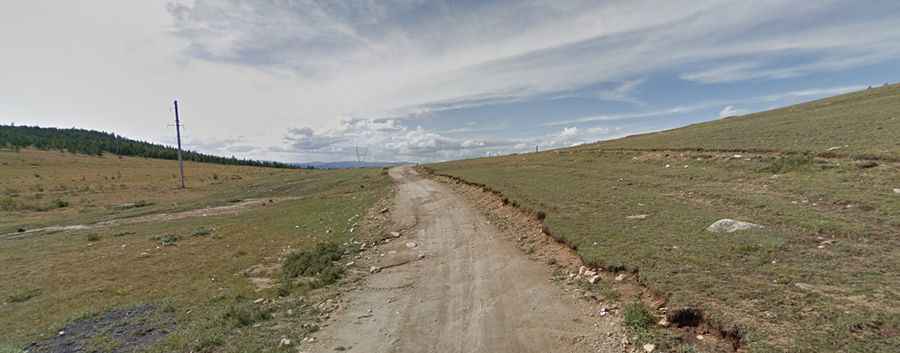
What are the road conditions on the Toom Pass in Khövsgöl?
The surface of the Toom Pass is a nightmare for standard vehicles. As seen on the approach, the road consists of deep, silty mud and patches of sharp rocks. When it rains, the track turns into a series of massive mud pits and bassals that can easily swallow a wheel and leave you high-centered. A high-clearance 4x4 is not optional; you need the traction to navigate the steep ramps and the clearance to avoid smashing your oil pan on the uneven ground. The road is constantly shifting due to erosion, and what was a passable track one day can become a muddy trap the next, especially in the higher sections near the 2,232m summit.
Why is a 4x4 mandatory for the Khoridol Saridag mountains?
The Khoridol Saridag range is one of the most unforgiving environments in northern Mongolia. The climb to the top of Toom Pass is steep and requires constant momentum to avoid getting bogged down in the soft, muddy sections. Without a proper low-range gearbox, you risk burning out your clutch while trying to crawl through the washouts. At an elevation of over 2,200 meters, your engine will also feel the drop in oxygen, making the steep climbs even more demanding. This is a journey for experienced off-roaders who know how to manage tire pressure and engine braking to avoid losing control on the long, slippery descents back toward Ulaan Ull.
When is the best time to drive the road to Toom Pass?
Due to its northern location and high altitude, Toom Pass is strictly seasonal. For most of the year, the 110 km track is buried under deep snow and is completely impassable. The best window for a crossing is during the peak summer months, but even then, you must watch the sky. Sudden summer storms can turn the dry dirt into a lethal slurry of mud in minutes. If you get caught in a storm near the summit, the descent becomes twice as dangerous as the climb. There is no cell service and very few landmarks, so make sure your vehicle is 100% sound and you have enough fuel and supplies to last several days if you get stuck in the mud.
Road suggested by: jorge manuel gómez sánchez