Road Trip Guide: Conquering Burkhatskiy Pass
Burkhatskiy Pass is a high mountain pass at an elevation of 2,137m (7,011ft) above sea level, located in the Katonkaragay district of the East Kazakhstan Region.
Where is Burkhatskiy Pass?
The pass is situated in the Sorvenok Valley, in the eastern part of Kazakhstan, within the Katon-Karagaisky State National Nature Park.
How Long is Burkhatskiy Pass?
Set high in the Sarym-Sakty Range, the road to the summit, also known as Burkhat Pass, is completely unpaved and referred to as the Austrian Road. It spans 108 km (67 miles), running north-south from Enbek (on Highway P-163) to Moyildy.
How Challenging is Burkhatskiy Pass?
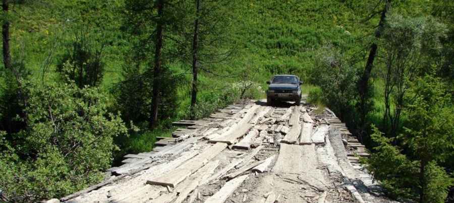
Avoid attempting to ascend the pass in rainy weather—the road can become extremely hazardous. A 4x4 vehicle is required, and it’s highly recommended not to travel alone. Before setting off, ensure you have adequate food and water as the journey is strenuous. The road traverses 16 bridges and fords with continuous hairpin turns. Due to the area’s remoteness, be prepared to camp overnight if necessary. On clear days, you’ll be rewarded with views of the Altai's highest peak, Mount Byelukha (4,506m), the tallest in all Siberia, from the summit.
When Was the Austrian Road Built?
The Austrian Road, mostly unpaved, was built from 1915 to 1917 as a strategic transport route across what is now the East Kazakhstan region. Constructed by Austro-Hungarian WWI prisoners—Czech, Slovak, Austrian, and Hungarian soldiers captured on the Eastern Front—this challenging track was forged through a remote wilderness using only basic tools like shovels, saws, pickaxes, and cables. Despite difficult climatic conditions, they managed to create a legendary route that stands as a tribute to their labor. Today, the Austrian Road is both a historical and natural landmark, honoring the resilience and determination of its builders.
More info&pics: http://silkadv.com/en/content/summer-kazakhstan