Is the Cliffside Shahi Route the Most Dangerous Road of Iran?
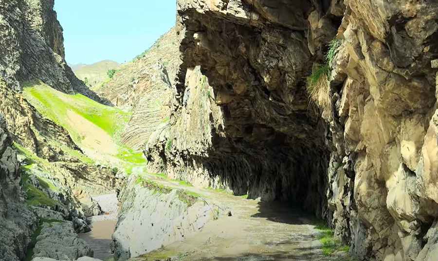
Shahi Road, also known as Rahi Shahi, is one of Iran’s most perilous and spectacular mountain roads. Nestled in the wild and remote terrain of Lorestan province, this unpaved cliffside path is infamous for its narrow width, hair-raising drops, and breathtaking views. Combining natural beauty with real danger, it offers a driving experience that’s not for the faint-hearted. This road is a relic left over from the construction of the national railway, which was built for the purpose of logistics.
Where is Shahi Road?
The road is located south of the city of Khorramabad, in Khorramabad County, in the Lorestan province, in the western part of the country. It runs through dense oak forests and mountainous terrain. The journey begins near the stunning Nojian Waterfall, one of the highest waterfalls in the country, and ends at the remote Keshvar Station, deep in the heart of the region.
When was Shahi Road Built?
This challenging road has a historical purpose, dating back to the 1920s. It was originally constructed as an access route to facilitate the development of Iran's national railway system, allowing workers and machinery to reach construction sites and future train stations. On the path of the national railway's construction, the road was built to transport personnel, equipment, and supplies, which became known as the supply road or royal road. A significant portion of this supply road was built along the mountain route between Durood and Andimeshk stations, extending for over 200 kilometers. Today, the Shahi Road was largely destroyed and unusable in many sections. However, it found a new purpose as a tourist and nature tourism attraction, where visitors could walk parts of it and enjoy the scenery. For much of its length, the Shahi Road ran alongside the Sezar River, which allowed for beautiful views of the river to be seen along the way.
How Long is Shahi Road and Where Does it Start and End?
The road spans approximately 20 kilometers (12.42 miles), running from Nojian Waterfall to Keshvar Station. It follows a north-to-south direction, winding through valleys, cliff faces, and forests, with numerous tight turns and steep sections along the way. The starting point, Nojian Waterfall, is one of the tallest waterfalls in Iran, adding to the scenic allure of the road.
Is the Shahi Road Unpaved?
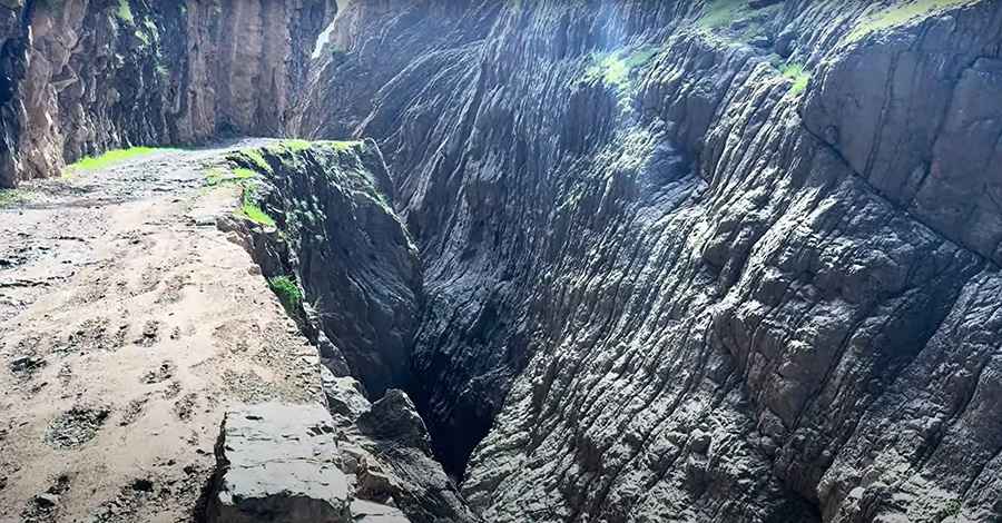
The Shahi Road is entirely unpaved and extremely narrow. In many places, it's no wider than a single car, making it impossible for two vehicles to pass. Drivers may be forced to reverse long distances along cliff edges. It’s common to walk sections of the road first to ensure they’re passable—some parts are that intimidating.
Why is Shahi Road Dangerous?
This route is among the most dangerous roads in Iran due to its extreme narrowness, total lack of guardrails, and dizzying drops into deep gorges. There’s no mobile signal in parts, and very little vehicle traffic, making breakdowns particularly risky. In sections, speeds drop to under 5 km/h. Local villagers often prefer walking rather than driving. A single misstep can result in disaster.
Is Shahi Road Worth the Drive?
The scenery is as stunning as it is wild. From dense forests and alpine meadows to sheer rock faces and roaring rivers, the route passes through untouched landscapes that few travelers ever see. Strange rock formations dot the cliffs, including one resembling a human face, silently watching over the path.
Why is Shahi Road Unforgettable?
Shahi Road offers a true off-road adventure. Travelers can stop mid-journey to rest, cook over an open fire, and soak in the raw beauty of nature. But the second half of the route ramps up in danger, with tighter paths, old bridges, and vertigo-inducing turns. It ends at Keshvar Station, a remote outpost that marks the end of a dramatic and unforgettable ride.
Road suggested by: Hugh Wilson
Pics&video: The Best Trip