Driving to Samamous Peak: The 3,686m ascent from Javaher Deh
Reaching an elevation of 3,686m (12,093ft) above sea level, Samamous Peak (also known as Somamous) is the highest point in the Gilan Province of Iran. Situated on the border between Mazandaran and Gilan, this peak is a landmark of the Alborz mountain range, offering a high-altitude driving challenge that is considered one of the highest roads in the country.
| Road facts: Samamous Peak | |
|---|---|
| Location | Mazandaran/Gilan Border, Iran |
| Elevation | 3,686 m (12,093 ft) |
| Length | 22.85 km (14.2 miles) |
| Elevation Gain | 1,959 m (6,428 ft) |
| Average Gradient | 8.57% |
Where is Samamous Peak?
The peak is located on the border between Mazandaran and Gilan provinces, in the northern part of Iran. It dominates the Alborz mountain range near the Caspian Sea. The most common access point for drivers is through the Sakht Sar Rural District in the Ramsar County. The geographic position makes it a unique transition zone where the humid Caspian air meets the dry high-altitude ridges.
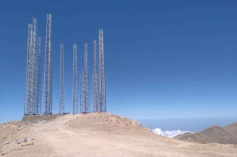
What’s at the summit of Samamous Peak?
The summit is crowned with strategic communication antennas and military facilities. These installations are the reason the road exists, as it was built to transport heavy equipment to the top. On clear days, the elevation offers a 360-degree panoramic view that stretches from Bandar Anzali to Bandar Nowshahr. It is common to stand at the summit and see a vast "sea of clouds" covering the valleys below, making it feel like you are driving on an island in the sky.
Is the road to Samamous Peak unpaved?
Yes, the road to the summit is totally unpaved and consists of loose rock, shale, and deep ruts. It is a "defiant" track that requires a high-clearance 4x4 vehicle. The drive is notorious for its dangerous drops and the complete absence of guardrails. The final section is particularly technical, with countless sharp hairpin turns where traction is a constant struggle. If you are prone to vertigo, the sheer exposure and narrow passages of this ridge road will be a significant challenge.
How long is the road to Samamous Peak?
Starting from the famous village of Javaher Deh, the road is 22.85 km (14.2 miles) long. Despite the relatively short distance, the elevation gain of 1,959m makes it a grueling journey that can take several hours. With an average gradient of 8.57%, the climb puts immense pressure on your vehicle’s cooling system. In winter and early spring, the road is buried under heavy snow and remains completely impassable. Even in summer, sudden fog can reduce visibility to zero, making the 22km stretch one of the most hazardous drives in Northern Iran.
Pic: mehdi msh