How to drive the Dharchula-Lipulekh Road to the Chinese border?
The Lipulekh Pass is an international high mountain crossing at an elevation of 5,099m (16,729ft) above sea level, situated on the border between India (Uttarakhand) and China (Tibet). The Dharchula-Lipulekh Road, completed in 2020, is a strategic extension of the Pithoragarh-Tawaghat-Ghatiabagarh route. This 25.9 km sector is a high-altitude military corridor that requires navigating extreme vertical gains and 61 sharp hairpin turns in one of the most rugged environments of the Himalayas.
| Road facts: Lipulekh Pass | |
|---|---|
| Location | India (Nabidhang) - China (Dingsong) |
| Elevation | 5,099m (16,729ft) |
| Length | 25.9 km (Sector Nabidhang to Dingsong) |
| Technical Features | 61 hairpin turns / Elevation gain +1,224m |
| Surface | Paved (mostly) / Subject to landslides |
What are the driving hazards of the 61 hairpins on Lipulekh Pass?
The 25.9 km transit between Nabidhang and Dingsong is characterized by 61 sharp hairpin turns. Managing these switchbacks at an altitude of 5,000 meters requires constant gear changes and precise steering. Due to the massive elevation gain of 1,224 meters, engines suffer from a significant loss of oxygen, which reduces torque. Drivers must maintain a steady RPM to avoid stalling in the middle of a hairpin, where the gradient is often at its steepest. The road is narrow, and meeting oncoming military convoys requires backing up to designated passing points, as the drop-offs into the valley are unprotected and vertical.
What is the logistical status of the Dharchula-Lipulekh road?
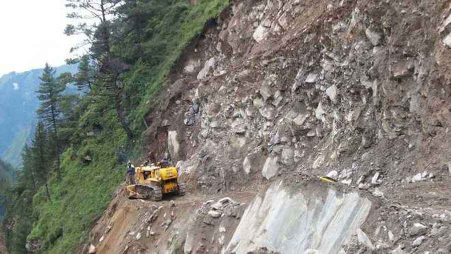
Logistically, the Dharchula-Lipulekh road is a primary supply line and is subject to strict military control. Although the road is mostly paved, the geological instability of the Himalayan range means that rockfalls and landslides are a constant technical hazard. A single landslide can block the entire 25.9 km sector for days. It is a mandatory safety protocol to monitor the weather in the Pithoragarh district, as heavy monsoon rains can wash out sections of the tarmac, turning the road into a mud-filled track. High-clearance 4x4 vehicles are recommended to navigate the debris that frequently litters the surface after minor rock slides.
How to manage vehicle performance at 5,099 meters?
Reaching the summit of Lipulekh Pass at 16,729ft is a test for any internal combustion engine. The atmospheric pressure is extremely low, which affects not only engine power but also the efficiency of the braking system. Continuous use of brakes during the 1,428m descent toward Tibet can lead to brake fade; utilizing engine braking is the only safe logistical approach for such a long decline. Before starting the ascent, verify that your cooling system is pressurized and that your battery is in peak condition, as cold starts at this altitude put an immense strain on the vehicle’s electrical components.
What are the cross-border logistics for Lipulekh Pass?
Lipulekh is a strategic border pass between India and China (Ngari Prefecture, Tibet). For any driver, the logistics of access are complex, involving multiple permits and security checkpoints. There is no civilian infrastructure, such as fuel stations or repair shops, for hundreds of kilometers. You must be 100% self-sufficient, carrying enough fuel to cover the extra consumption caused by the +1,224m climb. Communication is limited, and satellite phones are often the only way to contact emergency services. In winter, the pass is completely closed due to heavy snow accumulation and temperatures that fall below -30°C, making any attempt to transit technically impossible.
Pic: http://www.tribuneindia.com/news/uttarakhand/community/bro-begins-construction-work-on-lipulekh-pass-road/291855.html