Can civilians drive to Rezang La on the India-China border?
Rezang La, also known as Rechin La, is a high mountain pass at an elevation of 5,199m (17,057ft) above sea level, located on the Line of Actual Control (LAC) between Indian-administered Ladakh and the Chinese-administered Spanggur Lake basin. It's one of the highest roads in the country.
Set deep within the Himalayas, the pass is situated in an extremely quiet and desolate landscape with almost no vegetation. Due to its strategic location on the border, the area is heavily militarized. Access is strictly controlled; the military is the primary user of the road, and currently, only local residents and authorized personnel are permitted to visit this sensitive zone.
| Road facts: Rezang La | |
|---|---|
| Location | Ladakh (India) - China Border |
| Elevation | 5,199m (17,057ft) |
| Length from Tsaga | 18.3 km (11.3 miles) |
| Length from Jieso Gongma | 21.2 km (13.1 miles) |
| Surface | Gravel / Rocky |
How challenging is the road to Rezang La?
The road to the summit, known as Rezang La Road, is entirely unpaved. The surface is gravelly and rocky, becoming bumpy and technical in several sections. Driving at this altitude is a massive challenge for both vehicles and people; at over 5,000 meters, oxygen is in short supply, and altitude sickness is a serious risk for those not properly acclimated. A high-clearance 4x4 vehicle is mandatory to navigate the steep gradients and sharp hairpin curves. The pass is typically buried under snow and remains impassable during the winter months.
What is the historical significance of Rezang La?
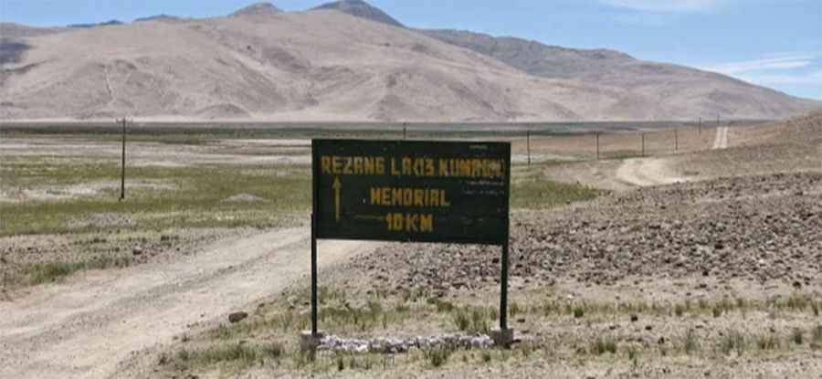
Beyond its geography, Rezang La is a site of immense historical importance. It was the location of the legendary "last stand" of the 13 Kumaon battalion during the Sino-Indian War in 1962. Near the summit, visitors will find the Rezang La War Memorial, which honors the soldiers who fought in extreme conditions at sub-zero temperatures. The memorial stands as a reminder of the pass's strategic role in the defense of the Chushul Valley.
How long is the drive to Rezang La?
There are two main approaches to the pass. Starting from Tsaga, the ascent covers 18.3 km (11.3 miles). Alternatively, starting from Jieso Gongma, the route spans 21.2 km (13.1 miles). Both paths are narrow and frequently used by heavy military convoys, requiring drivers to be extremely cautious and give way to military traffic at all times.
Pic: Raju Muthuswamy