Travel guide to the top of Shingo La Pass
Shingo La is a high mountain pass at an elevation of 5,048m (16,561ft) above sea level, located on the boundary between Jammu and Kashmir and Himachal Pradesh, in India.
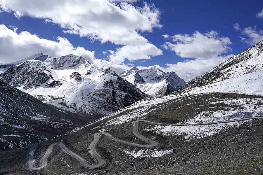
Is Shingo La unpaved?
The road to the summit, also known as Shinkun La, Shinku La, Shinkhun La, Shinkula Top, or Shingu La, is entirely paved and is called Shingo La Road. It's part of the Nimmu–Padum–Darcha road (NPDR) or Zanskar Highway, which was completed in 2024, on Monday, 25th.
When was the road through Shingo La built?
The first road through the pass was completed in 2012 after 10 years of construction. It was improved from 2014 to 2017. In 2021, the Border Roads Organisation (BRO) started to asphalt the road, and now the new metalled road has a capacity to carry truck loads of over 18 tonnes. The BRO is turning the road into a double-laned one and was fully paved in 2024.
How is the road through Shingo La?
Despite being fully paved, it is a very dangerous drive, with hairpin turns and a high risk of avalanches, heavy snowfalls, and landslides.
How long is Shingo La?
Located between Himachal’s Lahaul valley and Ladakh’s Zanskar valley, the pass is 56.8 km (35.29 miles) long, running south-north from Darcha to Kurgiakh through vast open plains, majestic mountains, and pristine lakes.
Is Shingo La open?
Set high in the northern part of the country, the area is prone to avalanches, and due to the heavy snowfalls in the region, it remains closed for vehicular activities from October onward till June every year.
When will Shingo La tunnel be built?
The BRO - through its newly formed Project Yojak - is constructing a 4.25 km tunnel under the pass for all-weather connectivity and attempting to keep the road open during the winter months. However, according to local conditions, the road will not remain open 24 hours and all days in the winter season due to heavy snowfall in the area which frequently blocks the approach road. The tunnel is expected to be completed by 2025.
Road suggested by: Hugh Wilson
Pic: Timothy A. Gonsalves. Own work, CC BY-SA 4.0, https://commons.wikimedia.org/w/index.php?curid=124319468