Tsang Chok La: Driving the 5,461m international pass between India and China
Tsang Chok La is an international mountain pass at an elevation of 5,461m (17,916ft) above sea level, situated on the boundary line between the Uttarkashi District (Uttarakhand, India) and Zanda County (Ngari Prefecture, Tibet Autonomous Region, China). The track crosses the high ridge of the Central Himalayas.
| Road facts: Tsang Chok La | |
|---|---|
| Location | Uttarakhand (India) - Tibet (China) Border |
| Elevation | 5,461 m (17,916 ft) |
| Indian Ascent Length | 18.9 km (11.7 miles) |
| Chinese Ascent Length | 12.5 km (7.7 miles) |
| Surface | Unpaved / Loose Dirt & Scree |
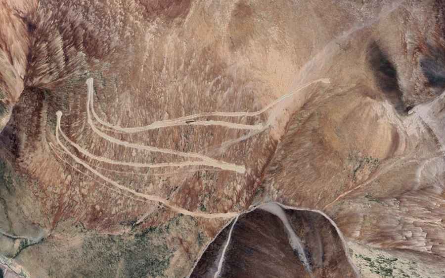
What is the road profile from the Indian side to Tsang Chok La?
The western approach originates at the military settlement of Pulam Sumda in the Uttarkashi District. The ascent to the 5,461-meter summit spans 18.9 km (11.7 miles), with a vertical elevation gain of 945 meters. The unpaved track maintains an average gradient of 5%, tracking through a continuous sequence of gravel switchbacks cut into the southern slopes of the mountain range.
What is the road profile from the Chinese side to Tsang Chok La?
The eastern approach links a junction on the unpaved Yeban Xian Road with the mountain crest. This segment is 12.5 km (7.7 miles) long, climbing 731 vertical meters with a steeper average gradient of 5.84%. The track surface consists of loose shale, granite sand, and mountain debris, featuring tight hairpin turns with narrow clearings next to the downhill drops.
What are the surface and traction conditions at Tsang Chok La?
The entire international pass is unpaved, alternating between loose dirt and unstable stone layers. Four-wheel-drive systems with high-clearance are required to clear ruts and maintain tire grip on the switchbacks. The edges of the single-lane track consist of natural soil shoulders without steel guardrails or concrete safety barriers. Water runoff from glacial melting triggers frequent rockfalls that deposit stones across the lanes.
How does weather affect the Tsang Chok La pass?
At 5,461 meters altitude, the pass remains covered under snowdrifts for most of the year, blocking vehicle access outside the summer months. Sudden blizzards reduce horizontal visibility below five meters and create ice layers over the dirt track. There are no roadside mechanics, fuel stations, or shelter infrastructure along the entire 31.4-kilometer drive.