Driving the world’s highest motorable road to Mig La Pass in Ladakh
In October 2025, the Border Roads Organisation (BRO) made history once again by completing the construction of the world’s highest motorable road at Mig La Pass. Reaching a staggering elevation of 19,400 ft (5,913 m), this new route in the Ladakh region of India has officially surpassed the previous Guinness World Record held by the nearby Umling La (19,024 ft). It's one of the highest roads in the country.
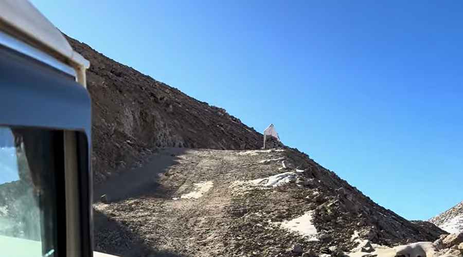
The road, officially known as the Likaru–Mig La–Fukche (LMLF) Road, is a 64-kilometer-long engineering marvel located in the Changthang Plateau, near the Line of Actual Control (LAC) with China. While the BRO and international records recognize this as the highest motorable pass, the debate over the world's absolute highest roads remains active among high-altitude enthusiasts. While Mig La is undoubtedly a giant, there are other remote tracks and mining roads across the globe that challenge for the top spot. You can explore the definitive ranking of the highest motorable road passes to see how Mig La stands against other Himalayan and Andean titans.
| Road facts: Mig La Pass | |
|---|---|
| Location | Leh District, Ladakh (India) |
| Elevation | 5,913 m (19,400 ft) |
| Route | Likaru – Mig La – Fukche (LMLF) |
| Construction | Project Himank (BRO) |
| Hazard Level | Extreme (Hypoxia & Sub-zero temperatures) |
| Permit | Inner Line Permit (ILP) Required |
How challenging is the drive to Mig La?
Driving to Mig La Pass is an expedition that pushes both man and machine to their absolute limits. The terrain is characterized by a cold desert climate where oxygen levels are nearly 50 per cent lower than at sea level. At 19,400 feet, the altitude is significantly higher than the South Base Camp of Mount Everest (17,598 feet). The construction of the LMLF road, carried out under Project Himank between August 2023 and October 2025, faced brutal geographical challenges, including loose soil, intense cold, and a working window restricted by extreme weather.
For drivers, the technicality of the road lies in the relentless ascent and the high-altitude performance of the vehicle. Engine power drops significantly due to the thin air, and the risk of Acute Mountain Sickness (AMS) is a constant threat. High-clearance 4x4 vehicles are mandatory, as the surface is subject to the harsh shifting conditions of the Changthang Plateau. Despite the smooth pavement in some sections, the sheer isolation and altitude make every kilometer a high-stakes endeavor.
Why is the Likaru–Mig La–Fukche road strategically important?
Beyond the record-breaking numbers, the LMLF road holds immense strategic significance for India. It establishes a third vital axis for military mobility from the Hanle sector to the Fukche Advanced Landing Ground, located just three kilometers from the border. This enhanced connectivity allows the Indian Armed Forces year-round access to the eastern Ladakh sector, ensuring operational readiness in one of the world's most sensitive border areas.
However, the road is not only for military use. Its opening is expected to boost tourism in the remote regions of Ladakh, providing easier access to breathtaking landscapes and cultural sites like the Hanle Observatory, Kyun Tso Lake, and Tso Moriri. By linking these remote "First Villages," the BRO aims to drive socio-economic development and uplift border communities that were previously isolated during the harsh winter months.
What should you prepare for when crossing Mig La?
A journey over Mig La requires meticulous planning. Travelers must obtain an Inner Line Permit (ILP) to enter this sensitive border zone. Preparation must include industrial-grade cold-weather gear, supplemental oxygen, and a fully serviced vehicle capable of handling extreme gradients in thin air. The weather at the summit can change in minutes, with sub-zero temperatures and gale-force winds being the norm. As you stand at the summit, marked by the Indian tricolour and the BRO flag, you are on a road that literally touches the edge of the sky—a testament to engineering dedication in the face of nature’s most extreme conditions.
Road suggested by: Hugh Wilson
Pic&video: Himalaya Wanderers