Longro La: Driving the unpaved military track of the Sumdorong Chu Valley
Deep in the heart of the eastern Himalayas, Longro La (also known as Langro La or Lungro La) is an international high mountain pass at an elevation of 4,340m (14,238ft) above sea level. This strategic crossing sits directly on the border between Arunachal Pradesh (India) and Cona County (Tibet, China), serving as a silent witness to the geopolitical complexities of the region.
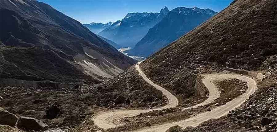
The road over Longro La is tucked away in the remote Sumdorong Chu Valley, an area known for its extreme isolation and military sensitivity. For overlanders, this is one of the most challenging tracks in the Himalayas, where the road is often more of a suggestion than a maintained surface. Due to its strategic location on the Indo-China border, the area is heavily monitored, and a special permit is strictly required to even approach the pass from either side.
| Road facts: Longro La | |
|---|---|
| Location | Arunachal Pradesh (India) - Tibet (China) |
| Elevation | 4,340 m (14,238 ft) |
| Length | 70 km (44 miles) |
| Route | Khinzemane to Zemithang |
| Status | Unpaved / Restricted Access |
How challenging is the road from Zemithang to Khinzemane?
The road through the pass spans 70 km (44 miles), running north-south and connecting the Indian settlement of Zemithang with Khinzemane. The entire stretch is totally unpaved and requires expert driving skills on mountain terrain. As you ascend, the notorious absence of oxygen at over 4,300 meters will test the limits of your vehicle's engine, which may lose significant torque and struggle to maintain momentum on the steepest ramps.
The track is characterized by sharp curves and loose gravel surfaces that are highly susceptible to landslides during the monsoon season and heavy snow drifts in the winter. If you are using a hired vehicle, it is paramount that the driver is an expert in snow-covered roads and high-altitude navigation. There are no facilities, fuel stations, or repair shops along this 70km stretch; total self-sufficiency is the only way to ensure a safe transit.
Winter survival and extreme climate hazards
Due to its high altitude and geographic position, Longro La remains closed for most of the year due to heavy snowfall. In winter, temperatures drop to life-threatening levels, and the pass becomes completely impassable even for heavy military machinery. Rapid weather changes are a constant factor—a clear morning can quickly turn into a blinding whiteout. Anyone attempting this route must be prepared with professional-grade cold-weather gear, extra fuel, and medical-grade oxygen to combat the onset of altitude sickness.
The strategic importance of the Sumdorong Chu Valley means that military patrols are frequent. Respecting local and international boundaries is vital, as straying off the designated track can lead to immediate detention. Longro La is a world-class adventure for those seeking the rawest edge of the Himalayas, but it is a route that leaves no margin for error or mechanical failure.
Pic: https://thenortheasttoday.com/states/arunachalpradesh/202-acres-sumdorong-chu-flash-point-to-give-india-strategic/cid2516226.htm