Khardung La is a difficult drive up to the top of a mountain
Khardung La is a high mountain pass at an elevation of 5,359m (17,582ft) above sea level, located in the Ladakh region of Jammu and Kashmir, India. It’s one of the highest roads in the world.
Is Khardung La the world's highest motorable road?
Contrary to popular belief fueled by Guinness World Records, social media posts, and even the signage at the mountain peak, the road to Khardung La is not the highest road on Earth. Recent GPS measurements have revealed that the reported elevation of 5,682m (18,641ft) is entirely inaccurate. To explore the genuinely highest roads on our planet, take a glimpse at our list of the highest roads on Earth.
Where is Khardung La?
The pass is the gateway to the Shyok and Nubra valleys. Maintained by the Border Roads Organisation, the pass is strategically important to India as it is used to carry supplies to the Siachen Glacier. The pass has been historically important as it lies on the major caravan route from Leh to Kashgar in Chinese Central Asia and is situated 39 km by road from Leh.
Can I drive through Khardung La?
Due to the proximity of the Pakistani and Chinese borders, massive Indian military presence in the area and associated military convoys cause additional problems, however, that’s nothing compared to what the altitude can do. A military checkpoint on the road requires a passport and a respective permit to ride the pass.
Is Khardung La paved?
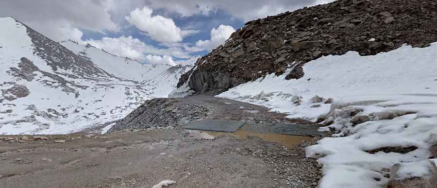
The road to the summit, also known as Khardong La and Khardzong La, is mostly paved (in bad conditions in parts). Hired vehicles (2 and 4-wheel drive), heavy trucks, and motorcycles regularly travel into the Nubra Valley, though special permits may need to be arranged for travelers to make the journey.
How long is the road through Khardung La?
The pass is 90km (56 miles) long, running south-north from Leh to Tsati. In favourable conditions, a 2wd vehicle can reach the summit, where you’ll find a couple of coffee shops.
When was the road to Khardung La built?
The narrow road to the summit was built in 1976 and opened to motor vehicles in 1988.
Is Khardung La dangerous?
The road is very well maintained (except in very few places where washouts or falling rock occur). It is often subject to long delays due to traffic congestion on narrow one-lane sections, washouts, landslides, and road accidents. It’s one of the highest roads in the country.
Is altitude sickness a risk on the road to Khardung La?
The pass features on many a die-hard cyclist’s bucket list. Anyone game enough to ride this ultra-long slog is likely to regret it as soon as they start pedaling. Acute Mountain Sickness (AMS) can start to affect people over 2,400m. Khardung Pass rises to well over double that, making those final kilometers absolutely agonizing. Altitude sickness is a serious health concern for travelers not previously acclimatized to high altitudes. Altitude sickness is guaranteed on this journey, and there is no medical support along the route. It is recommended to take deep breaths here as there is very less oxygen supply. Do not plan to spend more than 1-2 hours here. Don’t use the bathrooms at the summit. Extremely poor public conveniences and very gross toilets. Don’t even think about it.
Is Khardung La open?
The road is closed annually from approximately October to May due to snow. The road is usually covered in snow. It is a difficult journey during monsoons or during winters because there is always the risk of getting hit by avalanches.
Pic: Saurabh Arora