Chola Shan Pass
Chola Shan Pass is a high mountain pass at an elevation of 4.920m (16,141ft) above the sea level, located in Ngawa Tibetan and Qiang Autonomous Prefecture, an autonomous prefecture of northwestern Sichuan, in China.
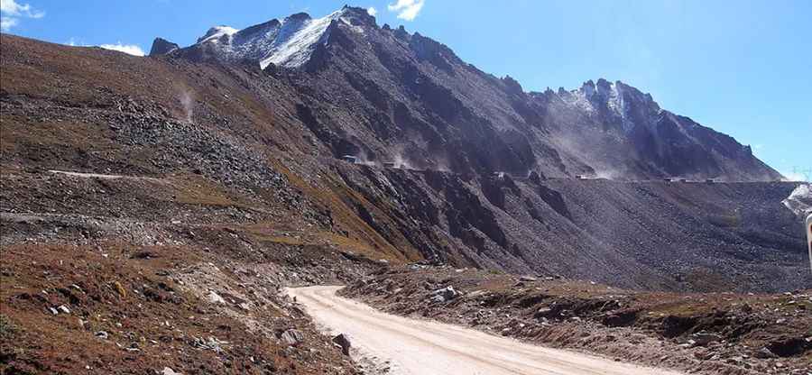
The road to the summit is mostly gravel which makes it a mud trap during the rainy season, and you will often come across thousand-car traffic jams stretching for miles. It’s called China National Highway 317. Many sections of the road are only single track, and driving long them in bad weather is a dangerous challenge to a less experienced driver. Rain, ice, snow and a host of other chilly winter challenges last for close to ten months making driving along this road a treacherous journey even for most experienced driver. Due to the high elevations and exposure, the road is subject to strong winds and rapid weather changes. Be prepared for the cold and wind! High winds blow here all year long. There are many dangerous sections of road along the route, and oxygen is scarce in the high altitude, making driving even more of a challenge. You can take a look at the Mount Gongga from a far distance.
The summit is also known as Tro La and Qo La. The summit is an icy-cold, windy and stunningly beautiful high mountain pass. The perilous dirt road winding up to the summit links Manigango and Derge. The monastery of Derge is one of the three most important monasteries in the Tibetan Buddhist religion because it is the main printing press monastery. The ascent is precipitous and switchback, gradually rising above the tree line into a world of jagged snow mountains. The road is dirty, a little bit bumpy, but the climb is very even and never more than a 5%. This treacherous mountain route is prone to landslides, avalanches, rockfalls, blizzards and ice. The summit offers fantastic views into the Chola Mountains. The pass has been bypassed by a new tunnel opened in 2017. The Cho La Mountain Tunnel is said to be one of the world’s highest road tunnel at an average altitude of 4.499 meters.
Pic: Pierre Margotat