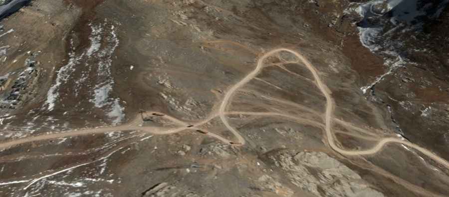
Bunggar La: A high-altitude mining track in the heart of Tibet
Bunggar La is a high-altitude pass that tests the mechanical limits of any vehicle. Reaching an elevation of 5,228m (17,152ft) above sea level in the Tibet Autonomous Region, this 12.8km track is a vital link for the region's mining operations. Located between Maizhokunggar and Lhari counties, the road is far from a scenic mountain drive; it is a working route where the loose surface and extreme gradients are secondary to the challenge of sharing the narrow path with heavy industrial traffic.
| Road facts: Bunggar La | |
|---|---|
| Location | Maizhokunggar/Lhari County, Tibet, China |
| Max Elevation | 5,228m (17,152ft) |
| Length | 12.8 km (7.9 miles) |
| Terrain | Unpaved, industrial mining track |
How is the climb through the 33 hairpins of Bunggar La?
The 12.8km transit between Mengya'a and Zhagaxiong is packed into a vertical climb that includes 33 sharp hairpin turns. Navigating these switchbacks on a totally unpaved surface requires a dedicated 4x4 vehicle with excellent torque management. The track is often covered in deep dust or thick mud, depending on the season, which makes traction unpredictable. The technical difficulty lies in the tightness of the turns; you are constantly adjusting the steering to avoid the ruts carved by heavy machinery.
Why is the mining traffic a danger on Bunggar La?
The defining characteristic of the road to Bunggar La is that it is heavily used by mining trucks. These are massive, high-tonnage vehicles that dominate the narrow track. For a standard 4x4, the primary risk is encountering one of these trucks on a hairpin or a narrow shelf section. The trucks often have the right of way due to their size and the difficulty of braking on a descent, so you must be prepared to reverse or find a wider spot to let them pass. The industrial nature of the road means the surface is constantly being reshaped by heavy tires, creating "corrugations" and loose edges that can easily trap a lighter vehicle if you get too close to the shoulder.
What are the effects of the 5,228m altitude on Bunggar La?
At an elevation of 5,228m, the Bunggar La is one of the highest driveable points in Lhasa prefecture. At this height, the oxygen levels are extremely low, which cripples the performance of internal combustion engines. You will notice a significant loss of power, and your cooling system will have to work overtime to keep the engine from overheating during the slow, high-revving climb. For the driver, the altitude can cause dizziness and slower reaction times. Managing the 33 hairpins of Bunggar La while dealing with hypoxia is a serious undertaking that requires frequent stops to check both the vehicle's vitals and your own physical condition.
Is the Bunggar La road passable all year round?
The road through Bunggar La is subject to the extreme volatility of Tibetan weather. Snow can block the pass even in the middle of summer, and the unpaved surface can turn into an impassable bog during periods of heavy precipitation. Given that this is a remote mining route, maintenance is focused on keeping the trucks moving, not on ensuring comfort for smaller vehicles. If you attempt the drive, you must be fully self-sufficient. A mechanical failure at 5,000 meters on a road filled with industrial traffic is a logistical nightmare; there are no services, and your only help might be a mining crew if you are lucky enough to find one with the right gear to pull you out.